
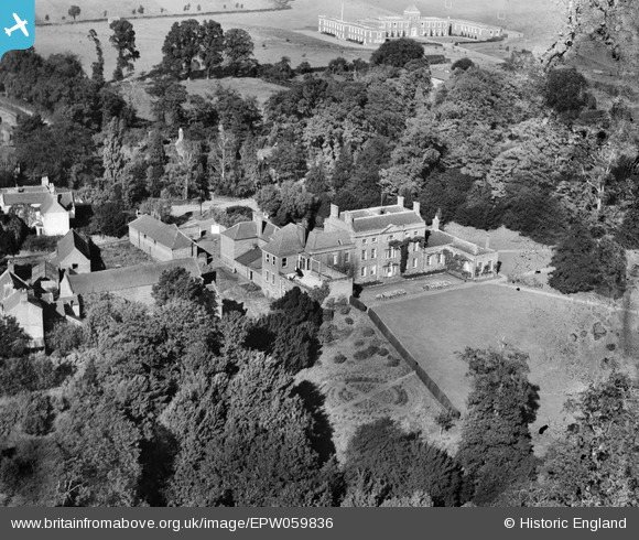
epw059836 ENGLAND (1938). Wolverley House, Wolverley, 1938
© Copyright OpenStreetMap contributors and licensed by the OpenStreetMap Foundation. 2026. Cartography is licensed as CC BY-SA.
Nearby Images (4)
EPW059836

EPW059842

EPW059837

EPW059838

Details
| Title | [EPW059836] Wolverley House, Wolverley, 1938 |
| Reference | EPW059836 |
| Date | 6-October-1938 |
| Link | |
| Place name | WOLVERLEY |
| Parish | WOLVERLEY AND COOKLEY |
| District | |
| Country | ENGLAND |
| Easting / Northing | 383019, 279608 |
| Longitude / Latitude | -2.2496871229866, 52.413829834737 |
| National Grid Reference | SO830796 |
Pins

SimonRae |
Monday 1st of July 2013 08:38:07 PM |
User Comment Contributions
The building shown at the top of the image is a school. Between 1948 and 1970 it was known as Sebright School and was a boys public boarding school. Pupils lived in various large houses in Wolverley. Although labeled as Wolverley House, the large house in the centre of the image was known as Eric Knight House in the 60s, in the late 60s the sixth-form boys (i.e. aged 17/18) boarded there. More information here: http://en.wikipedia.org/wiki/Wolverley. |
SimonRae |
Thursday 27th of June 2013 10:10:15 PM |