
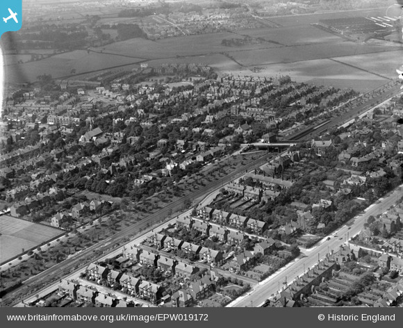
epw019172 ENGLAND (1927). Housing around Heaton Chapel and Heaton Moor Station, Heaton Moor, 1927
© Copyright OpenStreetMap contributors and licensed by the OpenStreetMap Foundation. 2025. Cartography is licensed as CC BY-SA.
Details
| Title | [EPW019172] Housing around Heaton Chapel and Heaton Moor Station, Heaton Moor, 1927 |
| Reference | EPW019172 |
| Date | August-1927 |
| Link | |
| Place name | HEATON MOOR |
| Parish | |
| District | |
| Country | ENGLAND |
| Easting / Northing | 388230, 391915 |
| Longitude / Latitude | -2.1771384509598, 53.42364034112 |
| National Grid Reference | SJ882919 |
Pins

Crispin Edwards |
Saturday 4th of January 2025 12:21:38 PM | |
|
Max Wild |
Saturday 7th of June 2014 03:22:56 PM | |
Permanent way staff kept the track side clear mainly because steam locomotives tended to throw sparks and start fires. This was a way of preventing that happening. |
John Wass |
Saturday 9th of May 2015 08:50:09 PM |
|
Gillian |
Wednesday 27th of November 2013 10:34:21 AM | |
|
totoro |
Wednesday 31st of July 2013 04:20:31 PM | |
|
totoro |
Wednesday 31st of July 2013 04:18:58 PM | |
|
totoro |
Wednesday 31st of July 2013 04:17:12 PM | |
|
John Ellis |
Friday 7th of December 2012 10:20:22 PM | |
|
John Ellis |
Friday 7th of December 2012 10:19:06 PM | |
|
John Ellis |
Friday 7th of December 2012 10:18:07 PM | |
|
John Ellis |
Friday 7th of December 2012 10:16:51 PM | |
|
MaxWild |
Thursday 29th of November 2012 12:46:29 PM | |
|
totoro |
Sunday 8th of July 2012 11:09:11 PM | |
|
totoro |
Sunday 8th of July 2012 11:04:34 PM | |
|
totoro |
Sunday 8th of July 2012 11:00:48 PM | |
|
totoro |
Sunday 8th of July 2012 10:58:53 PM | |
|
totoro |
Sunday 8th of July 2012 10:57:17 PM | |
|
totoro |
Sunday 8th of July 2012 10:56:08 PM | |
|
totoro |
Sunday 8th of July 2012 10:53:32 PM | |
|
totoro |
Sunday 8th of July 2012 10:52:00 PM | |
|
totoro |
Sunday 8th of July 2012 10:46:39 PM | |
I can't see sufficient detail to confirm this is the toilet but can confirm from memory that there was a small public gents toilet at the top of Egerton Road South on the railway side of the road. Where it stood is now behind the fencing and I think some evidence of it's existence may remain at ground level. It was open to the elements i.e. no roof and there were urinals but I can't remember whether there was a WC. It was always very drab and extremely smelly and I think it was built of some kind of glazed brick. |
Steve Delves |
Sunday 12th of October 2014 07:24:32 PM |
|
totoro |
Monday 2nd of July 2012 02:50:38 PM | |
Demolished July 2013!! |
MaxWild |
Monday 15th of July 2013 03:35:54 PM |
Again, I think that the actual site was a bit to the North (on a line with the foot bridge just visible over the railway) |
MaxWild |
Monday 15th of July 2013 03:43:19 PM |
Correct- I can't remove or amend this point so I've added a new one where it should be. |
totoro |
Wednesday 31st of July 2013 04:16:23 PM |
Now a building site for over 100 homes called Heaton Manor |
Max Wild |
Saturday 7th of June 2014 03:15:42 PM |
|
totoro |
Monday 2nd of July 2012 02:49:30 PM | |
|
totoro |
Monday 2nd of July 2012 02:48:59 PM | |
|
totoro |
Monday 2nd of July 2012 02:47:03 PM | |
|
totoro |
Friday 22nd of June 2012 01:36:31 PM | |
Tatton Road South |
Steve Delves |
Sunday 12th of October 2014 07:29:17 PM |
Tatton Road South |
Steve Delves |
Sunday 12th of October 2014 07:29:18 PM |
|
totoro |
Friday 22nd of June 2012 01:35:48 PM | |
Are you sure? I think that this too close the houses. The remains are actually in the sparse wood just above - I think!! |
MaxWild |
Monday 15th of July 2013 03:40:28 PM |
Correct - I can't amend or remove this point but have added a new one above. |
totoro |
Wednesday 31st of July 2013 04:19:44 PM |
|
totoro |
Friday 22nd of June 2012 01:34:36 PM |