
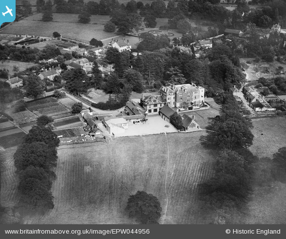
EPW044956 ENGLAND (1934). Lambrook School, Winkfield Row, 1934
© Copyright OpenStreetMap contributors and licensed by the OpenStreetMap Foundation. 2026. Cartography is licensed as CC BY-SA.
Nearby Images (14)
EPW044956

 0°
0m
0°
0m
EPW044958
 174°
20m
174°
20m
EPW044959
 222°
26m
222°
26m
EPW044957
 288°
31m
288°
31m
EPW044955
 299°
127m
299°
127m
EPW044954
 273°
130m
273°
130m
EPW044964
 296°
166m
296°
166m
EPW044953
 299°
174m
299°
174m
EPW044960
 310°
208m
310°
208m
EPW044952
 269°
209m
269°
209m
EPW044965
 266°
228m
266°
228m
EPW044961
 292°
236m
292°
236m
EPW044962
 306°
248m
306°
248m
EPW044963
 316°
279m
316°
279m
Details
| Title | [EPW044956] Lambrook School, Winkfield Row, 1934 |
| Reference | EPW044956 |
| Date | June-1934 |
| Link | |
| Place name | WINKFIELD ROW |
| Parish | WINKFIELD |
| District | |
| Country | ENGLAND |
| Easting / Northing | 489480, 171419 |
| Longitude / Latitude | -0.71260454030197, 51.434205144932 |
| National Grid Reference | SU895714 |
Pins
 Grove Lodge, Winkfield Row. In 1934 the house was three storeys high. The top floor was removed in the 1940s. Grove Lodge, Winkfield Row. In 1934 the house was three storeys high. The top floor was removed in the 1940s. |

BUNTYFROMBERKS |
Sunday 6th of December 2015 06:47:03 PM |