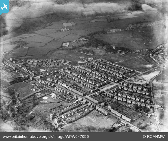
WPW047056 WALES (1935). View of Clydach showing 1930's housing estate, oblique aerial view. 5"x4" black and white glass plate negative.
© Copyright OpenStreetMap contributors and licensed by the OpenStreetMap Foundation. 2025. Cartography is licensed as CC BY-SA.
Nearby Images (8)
WPW047050

WPW047051

WPW047052

WPW047053

WPW047054

WPW047055

WPW047056

WPW049369

Details
| Title | [WPW047056] View of Clydach showing 1930's housing estate, oblique aerial view. 5"x4" black and white glass plate negative. |
| Reference | WPW047056 |
| Date | May-1935 |
| Link | Coflein Archive Item 6369972 |
| Place name | |
| Parish | |
| District | |
| Country | WALES |
| Easting / Northing | 268920, 201270 |
| Longitude / Latitude | -3.8967553368785, 51.694393476696 |
| National Grid Reference | SN689013 |
Pins

Class31 |
Monday 28th of January 2013 09:03:49 AM | |
|
Class31 |
Monday 28th of January 2013 09:00:45 AM | |
|
Class31 |
Monday 28th of January 2013 08:58:32 AM | |
|
Class31 |
Monday 28th of January 2013 08:54:46 AM | |
|
Class31 |
Monday 28th of January 2013 08:53:15 AM | |
|
Class31 |
Monday 26th of November 2012 03:26:35 PM | |
|
Class31 |
Monday 26th of November 2012 03:26:19 PM | |
|
Class31 |
Monday 26th of November 2012 03:26:02 PM | |

WILYROSUS |
Tuesday 26th of June 2012 12:30:09 PM | |
|
WILYROSUS |
Tuesday 26th of June 2012 12:29:29 PM | |
|
WILYROSUS |
Tuesday 26th of June 2012 12:28:47 PM | |
|
WILYROSUS |
Tuesday 26th of June 2012 12:27:38 PM | |
|
WILYROSUS |
Tuesday 26th of June 2012 12:19:30 PM | |
I am sorry but all the maps show this as Bryn Road. I can't find Twyn y Bedw Road on the map. |
Class31 |
Monday 28th of January 2013 09:25:11 AM |