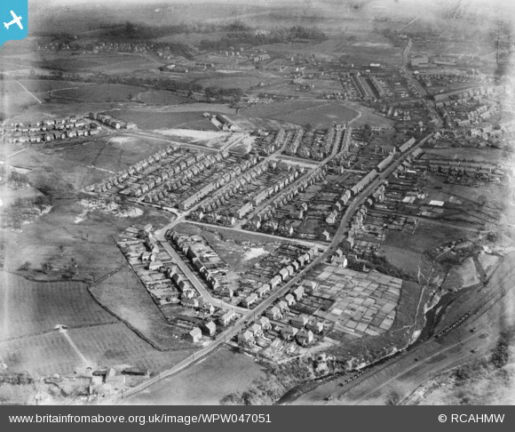
WPW047051 WALES (1935). View of Clydach showing 1930's housing estate, oblique aerial view. 5"x4" black and white glass plate negative.
© Copyright OpenStreetMap contributors and licensed by the OpenStreetMap Foundation. 2025. Cartography is licensed as CC BY-SA.
Nearby Images (8)
WPW047050

WPW047051

WPW047052

WPW047053

WPW047054

WPW047055

WPW047056

WPW049369

Details
| Title | [WPW047051] View of Clydach showing 1930's housing estate, oblique aerial view. 5"x4" black and white glass plate negative. |
| Reference | WPW047051 |
| Date | May-1935 |
| Link | Coflein Archive Item 6369967 |
| Place name | |
| Parish | |
| District | |
| Country | WALES |
| Easting / Northing | 268920, 201270 |
| Longitude / Latitude | -3.8967553368785, 51.694393476696 |
| National Grid Reference | SN689013 |
Pins

Class31 |
Monday 2nd of July 2012 01:06:56 PM | |
|
Class31 |
Monday 2nd of July 2012 01:06:33 PM | |
|
Class31 |
Monday 2nd of July 2012 01:06:16 PM | |
|
Class31 |
Monday 2nd of July 2012 01:05:54 PM | |
|
Class31 |
Monday 2nd of July 2012 01:05:33 PM | |
|
Class31 |
Monday 2nd of July 2012 10:26:48 AM |