
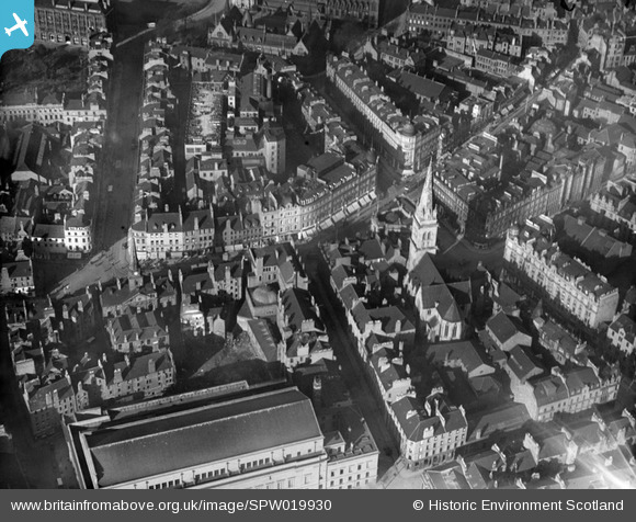
SPW019930 SCOTLAND (1927). Dundee, general view, showing High Street and St Paul's Episcopal Cathedral. An oblique aerial photograph taken facing north.
© Copyright OpenStreetMap contributors and licensed by the OpenStreetMap Foundation. 2026. Cartography is licensed as CC BY-SA.
Nearby Images (19)
SPW019930

SPW019935

SAW051265

SAW051263

SAW009822

SAW019553

SAW019548

SAW019549

SAW014833

SAW014835

SPW040561

SPW042547

SPW019925

SPW060072

SAW019551

SPW019936

SAW019554

SPW060076

SPW022110

Details
| Title | [SPW019930] Dundee, general view, showing High Street and St Paul's Episcopal Cathedral. An oblique aerial photograph taken facing north. |
| Reference | SPW019930 |
| Date | 1927 |
| Link | NRHE Collection item 1246334 |
| Place name | |
| Parish | DUNDEE (DUNDEE, CITY OF) |
| District | CITY OF DUNDEE |
| Country | SCOTLAND |
| Easting / Northing | 340380, 730300 |
| Longitude / Latitude | -2.9676060044797, 56.461171745305 |
| National Grid Reference | NO404303 |
Pins

hnritchie |
Wednesday 27th of August 2014 11:32:17 PM |