
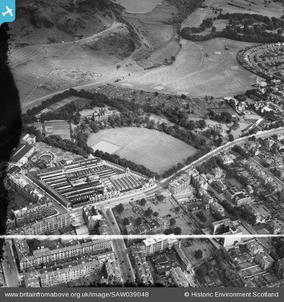
SAW039048 SCOTLAND (1951). Edinburgh, general view, showing St Leonard's Hall, Holyrood Park Road and Salisbury Green, Dalkeith Road. An oblique aerial photograph taken facing east. This image has been produced from a damaged and crop marked negative.
© Copyright OpenStreetMap contributors and licensed by the OpenStreetMap Foundation. 2026. Cartography is licensed as CC BY-SA.
Nearby Images (7)
SAW039047

SAW039048

SAW039046

SAW039044

SAW039045

SAW039050

SAW039049

Details
| Title | [SAW039048] Edinburgh, general view, showing St Leonard's Hall, Holyrood Park Road and Salisbury Green, Dalkeith Road. An oblique aerial photograph taken facing east. This image has been produced from a damaged and crop marked negative. |
| Reference | SAW039048 |
| Date | 1951 |
| Link | NRHE Collection item 1297641 |
| Place name | |
| Parish | EDINBURGH (EDINBURGH, CITY OF) |
| District | CITY OF EDINBURGH |
| Country | SCOTLAND |
| Easting / Northing | 326841, 672414 |
| Longitude / Latitude | -3.1713320357241, 55.939243207092 |
| National Grid Reference | NT268724 |
Pins

Starcross |
Friday 27th of January 2017 06:17:52 PM | |
|
Starcross |
Friday 27th of January 2017 06:17:31 PM | |
|
Tam Smith |
Friday 10th of May 2013 04:20:27 PM | |
|
Tam Smith |
Friday 10th of May 2013 04:19:13 PM |