
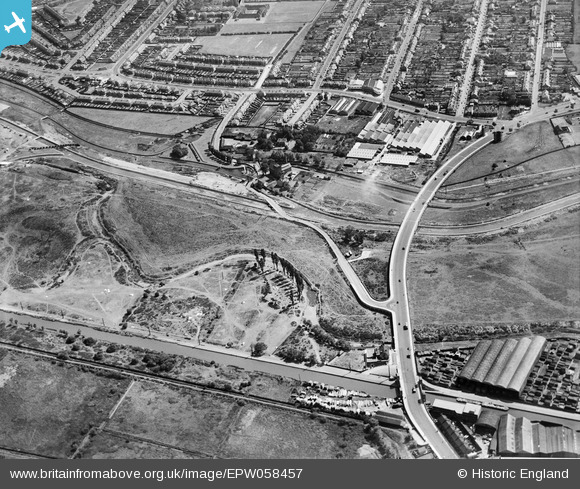
EPW058457 ENGLAND (1938). The North Circular Road Crossing the River Lea, Edmonton, 1938
© Copyright OpenStreetMap contributors and licensed by the OpenStreetMap Foundation. 2026. Cartography is licensed as CC BY-SA.
Nearby Images (28)
EPW058457

EPW058467

EPW052271

EPW056816

EPW053836

EPW056823

EPW056320

EPW055981

EPW050859

EPW056321

EPW052287

EPW052282

EPW055980

EPW056818

EPW053837

EPW018656

EAW037672
 Factory and the Cork Manufacturing Co Ltd Langite Works off Hall Lane, Chingford, 1951. This image has been produced from a print marked by Aerofilms Ltd for photo editing.")
EAW037671
 Factory, Flexo Plywood Works and the Cork Manufacturing Co Ltd Langite Works off Hall Lane, Chingford, 1951. This image has been produced from a print marked by Aerofilms Ltd for photo editing")
EAW037675
 Factory and the Cork Manufacturing Co Ltd Langite Works off Hall Lane, Chingford, 1951. This image has been produced from a print marked by Aerofilms Ltd for photo editing.")
EPW049529

EAW037670
 Factory, Flexo Plywood Works and the Cork Manufacturing Co Ltd Langite Works off Hall Lane, Chingford, 1951. This image has been produced from a print marked by Aerofilms Ltd for photo editing")
EPW049703

EPW060635

EAW037673
 Factory and the Cork Manufacturing Co Ltd Langite Works off Hall Lane, Chingford, 1951. This image has been produced from a print marked by Aerofilms Ltd for photo editing.")
EPW018565

EPW018561

EPW018567

EPW018563

Details
| Title | [EPW058457] The North Circular Road Crossing the River Lea, Edmonton, 1938 |
| Reference | EPW058457 |
| Date | 3-August-1938 |
| Link | |
| Place name | EDMONTON |
| Parish | |
| District | |
| Country | ENGLAND |
| Easting / Northing | 536153, 192425 |
| Longitude / Latitude | -0.033327742223933, 51.613696097956 |
| National Grid Reference | TQ362924 |
Pins
Be the first to add a comment to this image!