
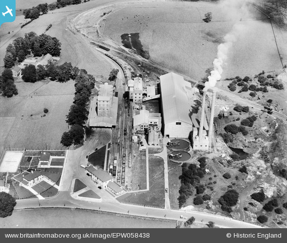
EPW058438 ENGLAND (1938). Ribble Cement Works, Horrocksford, 1938
© Copyright OpenStreetMap contributors and licensed by the OpenStreetMap Foundation. 2026. Cartography is licensed as CC BY-SA.
Nearby Images (6)
EPW058438

EPW058441

EPW058440

EPW058437

EPW058439

EPW058442

Details
| Title | [EPW058438] Ribble Cement Works, Horrocksford, 1938 |
| Reference | EPW058438 |
| Date | 26-July-1938 |
| Link | |
| Place name | HORROCKSFORD |
| Parish | CLITHEROE |
| District | |
| Country | ENGLAND |
| Easting / Northing | 374799, 443724 |
| Longitude / Latitude | -2.3834747513533, 53.888882062426 |
| National Grid Reference | SD748437 |
Pins

Dylan Moore |
Saturday 15th of June 2013 12:15:57 PM | |
|
Dylan Moore |
Saturday 15th of June 2013 12:15:24 PM | |
|
Dylan Moore |
Saturday 15th of June 2013 12:14:53 PM | |
|
Dylan Moore |
Saturday 15th of June 2013 12:14:26 PM | |
|
Dylan Moore |
Saturday 15th of June 2013 12:14:01 PM | |
|
Dylan Moore |
Saturday 15th of June 2013 12:13:22 PM | |
|
Dylan Moore |
Saturday 15th of June 2013 12:12:28 PM | |
|
Dylan Moore |
Saturday 15th of June 2013 12:12:02 PM | |
|
Dylan Moore |
Saturday 15th of June 2013 12:10:30 PM | |
|
Dylan Moore |
Saturday 15th of June 2013 12:09:58 PM | |
|
Dylan Moore |
Saturday 15th of June 2013 12:09:41 PM | |
|
Dylan Moore |
Saturday 15th of June 2013 12:09:22 PM | |
|
Dylan Moore |
Saturday 15th of June 2013 12:08:45 PM | |
|
Dylan Moore |
Saturday 15th of June 2013 12:08:23 PM |