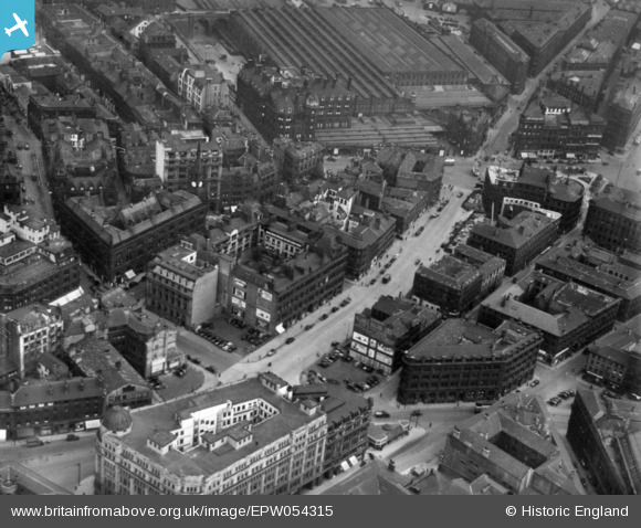
EPW054315 ENGLAND (1937). Market Street and environs, Bradford, 1937. This image has been produced from a print.
© Copyright OpenStreetMap contributors and licensed by the OpenStreetMap Foundation. 2026. Cartography is licensed as CC BY-SA.
Nearby Images (21)
Details
| Title | [EPW054315] Market Street and environs, Bradford, 1937. This image has been produced from a print. |
| Reference | EPW054315 |
| Date | 14-July-1937 |
| Link | |
| Place name | BRADFORD |
| Parish | |
| District | |
| Country | ENGLAND |
| Easting / Northing | 416474, 433114 |
| Longitude / Latitude | -1.7498881881503, 53.793860956891 |
| National Grid Reference | SE165331 |
Pins
Be the first to add a comment to this image!


![[EPW054315] Market Street and environs, Bradford, 1937. This image has been produced from a print.](http://britainfromabove.org.uk/sites/all/libraries/aerofilms-images/public/100x100/EPW/054/EPW054315.jpg)
![[EPW045329] Town Hall Square, the Exchange Railway Station and the city centre, Bradford, 1934](http://britainfromabove.org.uk/sites/all/libraries/aerofilms-images/public/100x100/EPW/045/EPW045329.jpg)
![[EPW052164] Market Street and the city centre, Bradford, 1936. This image has been produced from a print.](http://britainfromabove.org.uk/sites/all/libraries/aerofilms-images/public/100x100/EPW/052/EPW052164.jpg)
![[EPW057184] The Midland Railway Station, Market Street and the city centre, Bradford, 1938](http://britainfromabove.org.uk/sites/all/libraries/aerofilms-images/public/100x100/EPW/057/EPW057184.jpg)
![[EPW045330] Town Hall Square, the Exchange Railway Station and the city centre, Bradford, 1934](http://britainfromabove.org.uk/sites/all/libraries/aerofilms-images/public/100x100/EPW/045/EPW045330.jpg)
![[EPW054316] Market Street and environs, Bradford, 1937. This image has been produced from a print.](http://britainfromabove.org.uk/sites/all/libraries/aerofilms-images/public/100x100/EPW/054/EPW054316.jpg)
![[EPW054312] Bradford Town Hall and the city centre, Bradford, 1937](http://britainfromabove.org.uk/sites/all/libraries/aerofilms-images/public/100x100/EPW/054/EPW054312.jpg)
![[EPW054323] Forster Square and environs, Bradford, 1937. This image has been produced from a print.](http://britainfromabove.org.uk/sites/all/libraries/aerofilms-images/public/100x100/EPW/054/EPW054323.jpg)
![[EPW024505] The Town Hall and city centre, Bradford, 1928. This image has been produced from a print.](http://britainfromabove.org.uk/sites/all/libraries/aerofilms-images/public/100x100/EPW/024/EPW024505.jpg)
![[EPW024409] The town hall and city centre, Bradford, 1928](http://britainfromabove.org.uk/sites/all/libraries/aerofilms-images/public/100x100/EPW/024/EPW024409.jpg)
![[EPW057189] The City Hall, Bradford, 1938](http://britainfromabove.org.uk/sites/all/libraries/aerofilms-images/public/100x100/EPW/057/EPW057189.jpg)
![[EAW030800] The Exchange Railway Station and the city centre, Bradford, 1950](http://britainfromabove.org.uk/sites/all/libraries/aerofilms-images/public/100x100/EAW/030/EAW030800.jpg)
![[EPW057191] The City Hall, Bridge Street Goods Station and the city centre, Bradford, 1938](http://britainfromabove.org.uk/sites/all/libraries/aerofilms-images/public/100x100/EPW/057/EPW057191.jpg)
![[EPW054317] The Midland Hotel and Midland Railway Station, Bradford, 1937](http://britainfromabove.org.uk/sites/all/libraries/aerofilms-images/public/100x100/EPW/054/EPW054317.jpg)
![[EPW024394] Forster Square Station and environs, Bradford, 1928](http://britainfromabove.org.uk/sites/all/libraries/aerofilms-images/public/100x100/EPW/024/EPW024394.jpg)
![[EPW024395] The town hall and the city centre, Bradford, 1928](http://britainfromabove.org.uk/sites/all/libraries/aerofilms-images/public/100x100/EPW/024/EPW024395.jpg)
![[EPW054313] Town Hall Square and the city centre, Bradford, 1937](http://britainfromabove.org.uk/sites/all/libraries/aerofilms-images/public/100x100/EPW/054/EPW054313.jpg)
![[EAW049784] The Hirsch Son & Rhodes Ltd Warehouse off Manor Row and environs, Bradford, 1953. This image was marked by Aerofilms Ltd for photo editing.](http://britainfromabove.org.uk/sites/all/libraries/aerofilms-images/public/100x100/EAW/049/EAW049784.jpg)
![[EPW057183] The City Hall and the city centre, Bradford, 1938](http://britainfromabove.org.uk/sites/all/libraries/aerofilms-images/public/100x100/EPW/057/EPW057183.jpg)
![[EPW024392] The town hall and city centre, Bradford, 1928](http://britainfromabove.org.uk/sites/all/libraries/aerofilms-images/public/100x100/EPW/024/EPW024392.jpg)
![[EPW024521] The city centre, Bradford, 1928](http://britainfromabove.org.uk/sites/all/libraries/aerofilms-images/public/100x100/EPW/024/EPW024521.jpg)