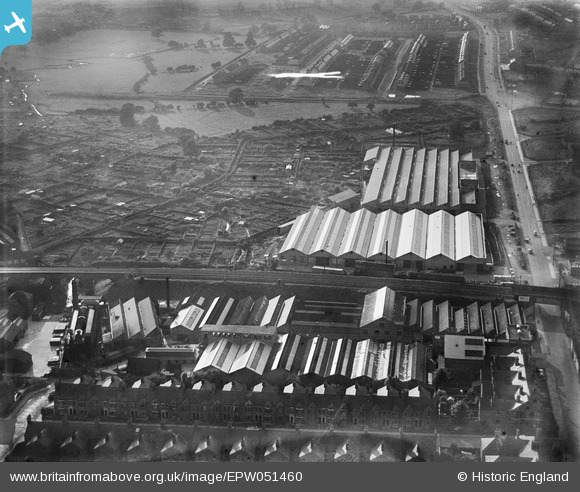
EPW051460 ENGLAND (1936). The Alvis Car and Engineering Co Works and adjacent allotment gardens, Spon End, 1936
© Copyright OpenStreetMap contributors and licensed by the OpenStreetMap Foundation. 2026. Cartography is licensed as CC BY-SA.
Nearby Images (29)
Details
| Title | [EPW051460] The Alvis Car and Engineering Co Works and adjacent allotment gardens, Spon End, 1936 |
| Reference | EPW051460 |
| Date | August-1936 |
| Link | |
| Place name | SPON END |
| Parish | |
| District | |
| Country | ENGLAND |
| Easting / Northing | 432225, 279358 |
| Longitude / Latitude | -1.5261968905488, 52.410896381767 |
| National Grid Reference | SP322794 |


![[EPW051460] The Alvis Car and Engineering Co Works and adjacent allotment gardens, Spon End, 1936](http://britainfromabove.org.uk/sites/all/libraries/aerofilms-images/public/100x100/EPW/051/EPW051460.jpg)
![[EPW044454] The Alvis Car and Engineering Works and allotment gardens off Holyhead Road, Coventry, 1934](http://britainfromabove.org.uk/sites/all/libraries/aerofilms-images/public/100x100/EPW/044/EPW044454.jpg)
![[EPW044453] The Alvis Car and Engineering Works, allotment gardens off Holyhead Road and environs, Coventry, 1934](http://britainfromabove.org.uk/sites/all/libraries/aerofilms-images/public/100x100/EPW/044/EPW044453.jpg)
![[EPW044455] The Alvis Car and Engineering Works and allotment gardens off Holyhead Road, Coventry, 1934](http://britainfromabove.org.uk/sites/all/libraries/aerofilms-images/public/100x100/EPW/044/EPW044455.jpg)
![[EPW051467] The Alvis Car and Engineering Co Works, Spon End, 1936](http://britainfromabove.org.uk/sites/all/libraries/aerofilms-images/public/100x100/EPW/051/EPW051467.jpg)
![[EPW051464] The Alvis Car and Engineering Co Works and environs, Spon End, 1936](http://britainfromabove.org.uk/sites/all/libraries/aerofilms-images/public/100x100/EPW/051/EPW051464.jpg)
![[EPW044457] The Alvis Car and Engineering Works and allotment gardens off Holyhead Road, Coventry, 1934](http://britainfromabove.org.uk/sites/all/libraries/aerofilms-images/public/100x100/EPW/044/EPW044457.jpg)
![[EPW051466] The Alvis Car and Engineering Co Works and environs, Spon End, 1936](http://britainfromabove.org.uk/sites/all/libraries/aerofilms-images/public/100x100/EPW/051/EPW051466.jpg)
![[EPW051459] The Alvis Car and Engineering Co Works and environs, Spon End, 1936](http://britainfromabove.org.uk/sites/all/libraries/aerofilms-images/public/100x100/EPW/051/EPW051459.jpg)
![[EPW046375] Alvis Motor Car and Engineering Works, housing development at Lammas Road and environs, Spon End, 1934](http://britainfromabove.org.uk/sites/all/libraries/aerofilms-images/public/100x100/EPW/046/EPW046375.jpg)
![[EPW051456] The Alvis Car and Engineering Co Works, Spon End, 1936](http://britainfromabove.org.uk/sites/all/libraries/aerofilms-images/public/100x100/EPW/051/EPW051456.jpg)
![[EPW051455] The Alvis Car and Engineering Co Works and environs, Spon End, 1936](http://britainfromabove.org.uk/sites/all/libraries/aerofilms-images/public/100x100/EPW/051/EPW051455.jpg)
![[EPW046376] Alvis Motor Car and Engineering Works, housing development at Lammas Road and environs, Spon End, 1934](http://britainfromabove.org.uk/sites/all/libraries/aerofilms-images/public/100x100/EPW/046/EPW046376.jpg)
![[EPW051463] The Alvis Car and Engineering Co Works and environs, Spon End, 1936](http://britainfromabove.org.uk/sites/all/libraries/aerofilms-images/public/100x100/EPW/051/EPW051463.jpg)
![[EPW051457] The Alvis Car and Engineering Co Works and environs, Spon End, 1936](http://britainfromabove.org.uk/sites/all/libraries/aerofilms-images/public/100x100/EPW/051/EPW051457.jpg)
![[EPW051461] The Alvis Car and Engineering Co Works and environs, Spon End, 1936](http://britainfromabove.org.uk/sites/all/libraries/aerofilms-images/public/100x100/EPW/051/EPW051461.jpg)
![[EPW051462] The Alvis Car and Engineering Co Works and environs, Spon End, 1936](http://britainfromabove.org.uk/sites/all/libraries/aerofilms-images/public/100x100/EPW/051/EPW051462.jpg)
![[EPW051454] The Alvis Car and Engineering Co Works and environs, Spon End, 1936](http://britainfromabove.org.uk/sites/all/libraries/aerofilms-images/public/100x100/EPW/051/EPW051454.jpg)
![[EPW051465] The Alvis Car and Engineering Co Works and environs, Spon End, 1936](http://britainfromabove.org.uk/sites/all/libraries/aerofilms-images/public/100x100/EPW/051/EPW051465.jpg)
![[EPW044451] The Alvis Car and Engineering Works, allotment gardens off Holyhead Road and environs, Coventry, 1934](http://britainfromabove.org.uk/sites/all/libraries/aerofilms-images/public/100x100/EPW/044/EPW044451.jpg)
![[EPW046377] Alvis Motor Car and Engineering Works, housing development at Lammas Road and environs, Spon End, 1934](http://britainfromabove.org.uk/sites/all/libraries/aerofilms-images/public/100x100/EPW/046/EPW046377.jpg)
![[EPW044452] The Alvis Car and Engineering Works, allotment gardens off Holyhead Road and environs, Coventry, 1934](http://britainfromabove.org.uk/sites/all/libraries/aerofilms-images/public/100x100/EPW/044/EPW044452.jpg)
![[EPW044456] The Alvis Car and Engineering Works, Coventry, 1934](http://britainfromabove.org.uk/sites/all/libraries/aerofilms-images/public/100x100/EPW/044/EPW044456.jpg)
![[EPW046374] Alvis Motor Car and Engineering Works and the Coventry Corporation Water Works, Spon End, 1934](http://britainfromabove.org.uk/sites/all/libraries/aerofilms-images/public/100x100/EPW/046/EPW046374.jpg)
![[EPW046379] Alvis Motor Car and Engineering Works, Spon End, 1934](http://britainfromabove.org.uk/sites/all/libraries/aerofilms-images/public/100x100/EPW/046/EPW046379.jpg)
![[EPW046373] Alvis Motor Car and Engineering Works and the Coventry Corporation Water Works, Spon End, 1934](http://britainfromabove.org.uk/sites/all/libraries/aerofilms-images/public/100x100/EPW/046/EPW046373.jpg)
![[EPW046378] Alvis Motor Car and Engineering Works and the Coventry Corporation Water Works, Spon End, 1934](http://britainfromabove.org.uk/sites/all/libraries/aerofilms-images/public/100x100/EPW/046/EPW046378.jpg)
![[EPW053106] The City, Coventry, from the west, 1937](http://britainfromabove.org.uk/sites/all/libraries/aerofilms-images/public/100x100/EPW/053/EPW053106.jpg)
![[EPW035780] Housing off Moseley Avenue, Barkers' Butts Lane and environs, Coventry, from the south-west, 1931](http://britainfromabove.org.uk/sites/all/libraries/aerofilms-images/public/100x100/EPW/035/EPW035780.jpg)
