
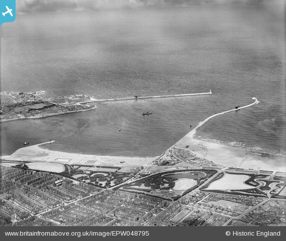
EPW048795 ENGLAND (1935). The North Pier, South Pier, and North and South Marine Parks and Bents Park, South Shields, from the south-west, 1935
© Copyright OpenStreetMap contributors and licensed by the OpenStreetMap Foundation. 2026. Cartography is licensed as CC BY-SA.
Nearby Images (3)
EPW048795

EAW022861

EPW048348

Details
| Title | [EPW048795] The North Pier, South Pier, and North and South Marine Parks and Bents Park, South Shields, from the south-west, 1935 |
| Reference | EPW048795 |
| Date | August-1935 |
| Link | |
| Place name | SOUTH SHIELDS |
| Parish | |
| District | |
| Country | ENGLAND |
| Easting / Northing | 437254, 567994 |
| Longitude / Latitude | -1.4174870745971, 55.005044038382 |
| National Grid Reference | NZ373680 |
Pins

N Dunn |
Tuesday 18th of September 2018 02:23:02 PM | |
|
Brigham |
Monday 8th of December 2014 01:45:20 PM | |
 |
N Dunn |
Tuesday 10th of December 2013 05:23:38 PM |

John Swain |
Wednesday 21st of August 2013 10:15:22 AM | |
|
John Swain |
Wednesday 21st of August 2013 10:01:16 AM | |
|
John Swain |
Wednesday 21st of August 2013 10:00:25 AM | |
|
John Swain |
Wednesday 21st of August 2013 09:59:26 AM | |
|
John Swain |
Wednesday 21st of August 2013 09:55:40 AM | |
|
John Swain |
Wednesday 21st of August 2013 09:53:44 AM | |
|
John Swain |
Wednesday 21st of August 2013 09:52:30 AM | |
|
John Swain |
Wednesday 21st of August 2013 09:51:03 AM | |
|
John Swain |
Wednesday 21st of August 2013 09:49:50 AM | |
|
John Swain |
Wednesday 21st of August 2013 09:49:00 AM | |
|
John Swain |
Wednesday 21st of August 2013 09:45:23 AM | |
|
John Swain |
Wednesday 21st of August 2013 09:44:45 AM | |
|
John Swain |
Wednesday 21st of August 2013 09:44:04 AM | |
|
John Swain |
Wednesday 21st of August 2013 09:43:10 AM | |
|
John Swain |
Wednesday 21st of August 2013 09:42:33 AM |
User Comment Contributions
The Baedeker Guide to Great Britain in 1937 describes South Shields as a seaport of 113,500 inhabitants and the part of this large town shown here has become a popular destination for daytrippers from throughout the North East. |
John Swain |
Wednesday 21st of August 2013 10:19:59 AM |