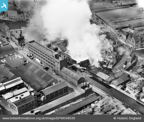
EPW048535 ENGLAND (1935). Extinguishing a fire at the Cardall's Timber & Joinery Co Saw Mill, Ladywood, 1935
    © Copyright OpenStreetMap contributors and licensed by the OpenStreetMap Foundation. 2025. Cartography is licensed as CC BY-SA.
  
Nearby Images (9)
Details
| Title | [EPW048535] Extinguishing a fire at the Cardall's Timber & Joinery Co Saw Mill, Ladywood, 1935 | 
| Reference | EPW048535 | 
| Date | July-1935 | 
| Link | |
| Place name | LADYWOOD | 
| Parish | |
| District | |
| Country | ENGLAND | 
| Easting / Northing | 406309, 286514 | 
| Longitude / Latitude | -1.9071020850751, 52.476149253671 | 
| National Grid Reference | SP063865 | 
Pins
|  access to Worcester wharf |   Martin | Saturday 22nd of February 2014 10:13:20 PM | 
|  Holliday Street |   Martin | Saturday 22nd of February 2014 10:12:39 PM | 
|  Boatmen's Mission Hall |   Martin | Saturday 22nd of February 2014 10:11:46 PM | 
|  Bridge Street |   Martin | Saturday 22nd of February 2014 10:07:40 PM | 
|  Willetts and Cobb Ltd. Platers and Polishers. |   Toby Clempson | Thursday 21st of November 2013 07:39:16 AM | 
|  The Worcester and Birmingham Canal. |   Toby Clempson | Thursday 21st of November 2013 07:37:55 AM | 
|  Gas Street. |   Toby Clempson | Thursday 21st of November 2013 07:37:34 AM | 
|  Gas Street Basin. |   Toby Clempson | Thursday 21st of November 2013 07:37:13 AM | 
User Comment Contributions
| This photograph shows a fire in premises close to Gas Street Basin and Gas Street seen on the left of the photograph, close to the City centre, and not in Ladywood. |   Toby Clempson | Thursday 21st of November 2013 07:40:10 AM | 
 
             
  ![[EPW048535] Extinguishing a fire at the Cardall's Timber & Joinery Co Saw Mill, Ladywood, 1935](http://britainfromabove.org.uk/sites/all/libraries/aerofilms-images/public/100x100/EPW/048/EPW048535.jpg) 
  
                                          ![[EPW048534] Extinguishing a fire at the Cardall's Timber & Joinery Co Saw Mill, Ladywood, 1935](http://britainfromabove.org.uk/sites/all/libraries/aerofilms-images/public/100x100/EPW/048/EPW048534.jpg) 
 ![[EAW015328] The city centre, Birmingham, from the south, 1948. This image has been produced from a print.](http://britainfromabove.org.uk/sites/all/libraries/aerofilms-images/public/100x100/EAW/015/EAW015328.jpg) 
 ![[EPW048092] The Hall of Memory, Central Goods Station and environs, Birmingham, 1935](http://britainfromabove.org.uk/sites/all/libraries/aerofilms-images/public/100x100/EPW/048/EPW048092.jpg) 
 ![[EAW031628] Easy Row and the city centre, Birmingham, from the south-west, 1950](http://britainfromabove.org.uk/sites/all/libraries/aerofilms-images/public/100x100/EAW/031/EAW031628.jpg) 
 ![[EPW041474] The Hall of Memory and environs, Birmingham, from the south-west, 1933](http://britainfromabove.org.uk/sites/all/libraries/aerofilms-images/public/100x100/EPW/041/EPW041474.jpg) 
 ![[EAW035106] Broad Street and environs, Birmingham, 1951](http://britainfromabove.org.uk/sites/all/libraries/aerofilms-images/public/100x100/EAW/035/EAW035106.jpg) 
 ![[EAW035105] Broad Street and environs, Birmingham, 1951](http://britainfromabove.org.uk/sites/all/libraries/aerofilms-images/public/100x100/EAW/035/EAW035105.jpg) 
 ![[EPW054234] The city centre, Birmingham, from the south-east, 1937](http://britainfromabove.org.uk/sites/all/libraries/aerofilms-images/public/100x100/EPW/054/EPW054234.jpg)