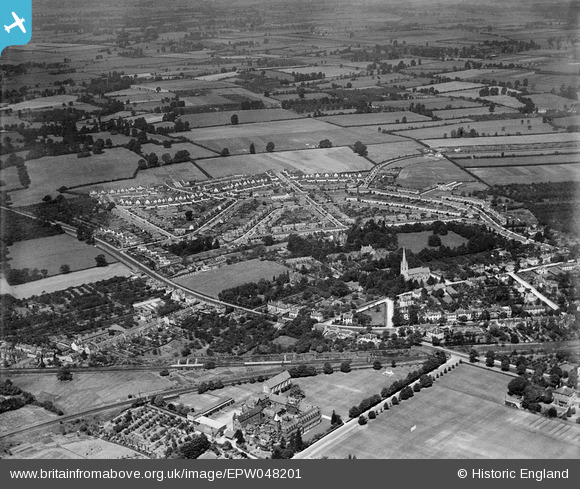
EPW048201 ENGLAND (1935). Dean Close Memorial School, the St Mark's estate and environs, Cheltenham, from the south-east, 1935
© Copyright OpenStreetMap contributors and licensed by the OpenStreetMap Foundation. 2026. Cartography is licensed as CC BY-SA.
Details
| Title | [EPW048201] Dean Close Memorial School, the St Mark's estate and environs, Cheltenham, from the south-east, 1935 |
| Reference | EPW048201 |
| Date | July-1935 |
| Link | |
| Place name | CHELTENHAM |
| Parish | |
| District | |
| Country | ENGLAND |
| Easting / Northing | 392760, 221961 |
| Longitude / Latitude | -2.1052274549403, 51.895713202725 |
| National Grid Reference | SO928220 |
Pins

Toby Clempson |
Friday 23rd of December 2016 07:35:17 AM | |

Richcl |
Sunday 5th of May 2013 11:35:01 AM | |

Richcl |
Sunday 5th of May 2013 11:33:44 AM | |

Richcl |
Sunday 5th of May 2013 11:32:16 AM | |

Richcl |
Sunday 5th of May 2013 11:31:10 AM | |

Richcl |
Sunday 5th of May 2013 11:30:00 AM | |

Richcl |
Sunday 5th of May 2013 11:29:08 AM | |

Richcl |
Sunday 5th of May 2013 11:28:32 AM | |

Richcl |
Sunday 5th of May 2013 11:28:02 AM | |

Richcl |
Sunday 5th of May 2013 11:27:44 AM |
User Comment Contributions
Distant view of St. Mark's Church from the top deck of bus 94 on Gloucester Road 27/09/2013 |

Class31 |
Monday 30th of September 2013 09:23:46 AM |


![[EPW048201] Dean Close Memorial School, the St Mark's estate and environs, Cheltenham, from the south-east, 1935](http://britainfromabove.org.uk/sites/all/libraries/aerofilms-images/public/100x100/EPW/048/EPW048201.jpg)
![[EPW024136] St Mark's Estate, Cheltenham, from the south, 1928](http://britainfromabove.org.uk/sites/all/libraries/aerofilms-images/public/100x100/EPW/024/EPW024136.jpg)
![[EPW048202] The St Mark's estate and environs, Cheltenham, from the south-east, 1935](http://britainfromabove.org.uk/sites/all/libraries/aerofilms-images/public/100x100/EPW/048/EPW048202.jpg)