
EPW047553 ENGLAND (1935). The former works of De Havilland at Stag Lane and surrounding housing development, Queensbury, 1935

© Copyright OpenStreetMap contributors and licensed by the OpenStreetMap Foundation. 2026. Cartography is licensed as CC BY-SA.
Nearby Images (48)
EPW047553

EPW022048

EPW032889

EPW047550

EPW009129

EPW032892

EPW013196

EPW047556

EPW013198

EPW032890

EPW031547

EPW046489

EPW034987

EPW046486

EPW034797

EPW047557

EPW047554

EPW022364

EPW046490

EPW047552

EPW018765

EPW047549

EPW025073

EPW025074

EPW030058

EPW030057

EPW046487

EPW034980

EPW034980
EPW034981

EPW034981
EPW018148

EPW017872

EPW017873

EPW017874

EPW017875

EPW017876

EPW017877

EPW017878

EPW017880

EPW035010

EPW018132

EPW046485

EPW025691

EPW030056

EPW031582

EPW035016

EPW031546

Details
| Title | [EPW047553] The former works of De Havilland at Stag Lane and surrounding housing development, Queensbury, 1935 |
| Reference | EPW047553 |
| Date | June-1935 |
| Link | |
| Place name | QUEENSBURY |
| Parish | |
| District | |
| Country | ENGLAND |
| Easting / Northing | 519572, 190114 |
| Longitude / Latitude | -0.27349621523702, 51.596691180311 |
| National Grid Reference | TQ196901 |
Pins

Sydney Paul |
Wednesday 12th of March 2014 12:30:40 PM | |
|
Sydney Paul |
Wednesday 12th of March 2014 12:25:22 PM | |
|
Sydney Paul |
Wednesday 12th of March 2014 12:23:11 PM | |
|
Sydney Paul |
Wednesday 12th of March 2014 12:21:04 PM | |
|
Sydney Paul |
Wednesday 12th of March 2014 12:19:47 PM | |
|
Sydney Paul |
Wednesday 12th of March 2014 12:18:10 PM | |
|
Sydney Paul |
Wednesday 12th of March 2014 12:16:03 PM | |
|
colsouth111 |
Monday 10th of June 2013 10:50:50 AM |
User Comment Contributions
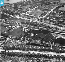
Looking across from Holyrood Gns and the Dehaviland factory we can see a square of empty land that is the site of Stag Lane primary school. Indeed those huts may be any early manifestation of that establishment. The roads all around it are named after famous artists. |
colsouth111 |
Thursday 27th of June 2013 08:01:15 PM |