
EPW022048 ENGLAND (1928). Stag Lane Aerodrome, Queensbury, 1928

© Copyright OpenStreetMap contributors and licensed by the OpenStreetMap Foundation. 2026. Cartography is licensed as CC BY-SA.
Nearby Images (48)
EPW022048

EPW047553

EPW032889

EPW047550

EPW009129

EPW013198

EPW047556

EPW013196

EPW032892

EPW032890

EPW046486

EPW034987

EPW046489

EPW031547

EPW047557

EPW047554

EPW034797

EPW046490

EPW047552

EPW018765

EPW022364

EPW047549

EPW025073

EPW025074

EPW030058

EPW030057

EPW034980

EPW034980
EPW046487

EPW017872

EPW017873

EPW017874

EPW017875

EPW017876

EPW017877

EPW017878

EPW017880

EPW018132

EPW034981

EPW034981
EPW018148

EPW046485

EPW035010

EPW025691

EPW030056

EPW035016

EPW031582

EPW031546

Details
| Title | [EPW022048] Stag Lane Aerodrome, Queensbury, 1928 |
| Reference | EPW022048 |
| Date | July-1928 |
| Link | |
| Place name | QUEENSBURY |
| Parish | |
| District | |
| Country | ENGLAND |
| Easting / Northing | 519576, 190106 |
| Longitude / Latitude | -0.27344121464451, 51.596618424863 |
| National Grid Reference | TQ196901 |
Pins
Be the first to add a comment to this image!
User Comment Contributions
Could be Stag Lane |

Peanut |
Wednesday 26th of March 2014 11:46:34 AM |
Definitely Stag Lane with Dehavilland factory - from south |
Sydney Paul |
Wednesday 26th of March 2014 11:46:34 AM |
Dear all, That's great; we've reviewed your suggestions and thanks to your help we can update the catalogue. The revised record will appear here in due course. Hope you have the same success solving some of our other mysteries! Katy Whitaker Britain from Above Cataloguer |
Katy Whitaker |
Monday 2nd of July 2012 11:41:43 AM |
I agree, think Stag Lane is a good bet for this one so I've put a pin on the map. |
Whittocks |
Sunday 1st of July 2012 01:20:42 PM |
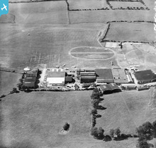
Anyone care to try to identify things in EPW022048 |
BigglesH |
Thursday 28th of June 2012 01:42:49 PM |
An Airfield (you can see the planes). Surprisingly active. Manufacturing site ? |
BigglesH |
Tuesday 26th of June 2012 09:51:30 PM |