
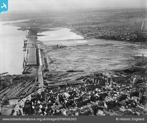
EPW041063 ENGLAND (1933). Reclamation of the Western Docks between Royal Pier and Millbrook, Southampton, from the south-east, 1933
© Copyright OpenStreetMap contributors and licensed by the OpenStreetMap Foundation. 2026. Cartography is licensed as CC BY-SA.
Nearby Images (6)
EPW041063

EPW020447

EPW032341

EPW042962

EAW001354

EAW001359

Details
| Title | [EPW041063] Reclamation of the Western Docks between Royal Pier and Millbrook, Southampton, from the south-east, 1933 |
| Reference | EPW041063 |
| Date | April-1933 |
| Link | |
| Place name | SOUTHAMPTON |
| Parish | |
| District | |
| Country | ENGLAND |
| Easting / Northing | 441777, 111243 |
| Longitude / Latitude | -1.4058630431313, 50.898598664321 |
| National Grid Reference | SU418112 |
Pins

ARussel |
Saturday 18th of September 2021 10:48:56 PM | |

Class31 |
Thursday 12th of February 2015 08:27:57 PM | |
 |
Class31 |
Thursday 12th of February 2015 08:23:29 PM |
|
Class31 |
Thursday 12th of February 2015 08:22:49 PM | |
|
Class31 |
Thursday 12th of February 2015 08:21:39 PM | |
|
Class31 |
Thursday 12th of February 2015 08:19:06 PM | |
|
Class31 |
Thursday 12th of February 2015 08:17:47 PM |


User Comment Contributions
Western Docks, Southampton, 12/02/2015 |
Class31 |
Thursday 12th of February 2015 08:16:18 PM |