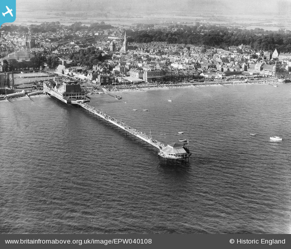
EPW040108 ENGLAND (1932). The pier and the town, Bognor Regis, from the south, 1932
    © Copyright OpenStreetMap contributors and licensed by the OpenStreetMap Foundation. 2025. Cartography is licensed as CC BY-SA.
  
Nearby Images (7)
Details
| Title | [EPW040108] The pier and the town, Bognor Regis, from the south, 1932 | 
| Reference | EPW040108 | 
| Date | August-1932 | 
| Link | |
| Place name | BOGNOR REGIS | 
| Parish | BOGNOR REGIS | 
| District | |
| Country | ENGLAND | 
| Easting / Northing | 493479, 98547 | 
| Longitude / Latitude | -0.67396866587135, 50.778391308429 | 
| National Grid Reference | SZ935985 | 
 
             
  ![[EPW040108] The pier and the town, Bognor Regis, from the south, 1932](http://britainfromabove.org.uk/sites/all/libraries/aerofilms-images/public/100x100/EPW/040/EPW040108.jpg) 
  
                                          ![[EAW046504] The pier and town, Bognor Regis, from the south, 1952](http://britainfromabove.org.uk/sites/all/libraries/aerofilms-images/public/100x100/EAW/046/EAW046504.jpg) 
 ![[EAW046804] The pier and the town, Bognor Regis, from the east, 1952](http://britainfromabove.org.uk/sites/all/libraries/aerofilms-images/public/100x100/EAW/046/EAW046804.jpg) 
 ![[EAW046503] The pier and town, Bognor Regis, from the south-east, 1952](http://britainfromabove.org.uk/sites/all/libraries/aerofilms-images/public/100x100/EAW/046/EAW046503.jpg) 
 ![[EAW046803] The pier and the town, Bognor Regis, from the south, 1952](http://britainfromabove.org.uk/sites/all/libraries/aerofilms-images/public/100x100/EAW/046/EAW046803.jpg) 
 ![[EAW022233] The Pier and the town, Bognor Regis, from the south-east, 1949](http://britainfromabove.org.uk/sites/all/libraries/aerofilms-images/public/100x100/EAW/022/EAW022233.jpg) 
 ![[EAW022235] The Pier and the town, Bognor Regis, from the south-east, 1949](http://britainfromabove.org.uk/sites/all/libraries/aerofilms-images/public/100x100/EAW/022/EAW022235.jpg) 
  Pavilion (fire damaged in 1948/49)
 Pavilion (fire damaged in 1948/49)