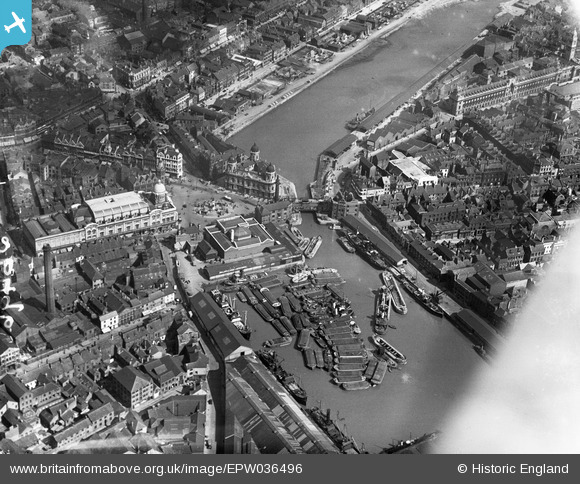
EPW036496 ENGLAND (1931). Prince's Dockand environs, Kingston upon Hull, 1931
    © Copyright OpenStreetMap contributors and licensed by the OpenStreetMap Foundation. 2025. Cartography is licensed as CC BY-SA.
  
Nearby Images (10)
Details
| Title | [EPW036496] Prince's Dockand environs, Kingston upon Hull, 1931 | 
| Reference | EPW036496 | 
| Date | August-1931 | 
| Link | |
| Place name | KINGSTON UPON HULL | 
| Parish | |
| District | |
| Country | ENGLAND | 
| Easting / Northing | 509664, 428719 | 
| Longitude / Latitude | -0.33699719504328, 53.743077487979 | 
| National Grid Reference | TA097287 | 
Pins
|  The dockside railway track and the tram lines are interwoven here as the tramlines have a centre groove flange-way which was unique to Hull. |   John Wass | Thursday 8th of February 2018 11:20:50 AM | 
| Not quite unique, as centre groove rails were also used in Doncaster. |   mannidaze | Thursday 5th of December 2019 05:21:42 PM | 
|  A tram on the Anlaby Road service emerging from Chariot Street after circulating the City Hall to reverse direction. |   John Wass | Friday 4th of August 2017 07:54:51 PM | 
|  Waterhouse Lane, this was once Hulls Red Light District. |   CartoonHead | Sunday 1st of November 2015 05:02:40 PM | 
|  A start has been made on filling this dock in. |   John Wass | Saturday 1st of August 2015 04:39:20 PM | 
|  The Criterion cinema in the 1940s and 50s. Previously the Majestic? |   Hargow | Monday 13th of July 2015 02:01:02 PM | 
|  Field's cafe, famous for the delicious smell of roasting coffee beans |   Hargow | Monday 13th of July 2015 01:48:23 PM | 
|  Trams (Horse powered)also ran down this street, that being Whitefriargate in this instance. |   John Wass | Monday 5th of January 2015 02:46:02 PM | 
|  Dock offices |   MB | Wednesday 26th of December 2012 11:15:22 AM | 
|  George Street. This street was part of Hull's tramway system |   MB | Wednesday 26th of December 2012 11:13:56 AM | 
|  Tramway ran down this street |   MB | Wednesday 26th of December 2012 11:12:48 AM | 
| That street is Alfred Gelder Street. |   John Wass | Friday 28th of November 2014 11:16:26 AM | 
|  Whitefriargate Bridge. A lifting bridge of the bascule type |   MB | Wednesday 26th of December 2012 11:12:17 AM | 
| Always known to us natives as Monument Bridge. |   John Wass | Friday 4th of August 2017 07:52:10 PM | 
|  Osborne Street. This was the end of a tram line |   MB | Wednesday 26th of December 2012 11:10:57 AM | 
|  Tramline. The tramway made a circuit of City Hall |   MB | Wednesday 26th of December 2012 11:09:51 AM | 
|  Queen Victoria Square |   MB | Wednesday 26th of December 2012 11:08:34 AM | 
|  Art gallery |   MB | Wednesday 26th of December 2012 11:07:59 AM | 
|  City Hall |   MB | Wednesday 26th of December 2012 11:07:40 AM | 
|   MB | Wednesday 26th of December 2012 11:07:07 AM | |
|  Charles Holmes & Co Ltd |   MB | Wednesday 26th of December 2012 11:06:07 AM | 
|  Dredger with steam crane - it appears - loading barge with dock silt |   MB | Wednesday 26th of December 2012 11:03:20 AM | 
 
             
  ![[EPW036496] Prince's Dockand environs, Kingston upon Hull, 1931](http://britainfromabove.org.uk/sites/all/libraries/aerofilms-images/public/100x100/EPW/036/EPW036496.jpg) 
  
                                          ![[EPW036497] Whitefriargate Bridge and Queen Victoria Square, Kingston upon Hull, 1931](http://britainfromabove.org.uk/sites/all/libraries/aerofilms-images/public/100x100/EPW/036/EPW036497.jpg) 
 ![[EPW012805] Queen Victoria Square, Kingston upon Hull, 1925](http://britainfromabove.org.uk/sites/all/libraries/aerofilms-images/public/100x100/EPW/012/EPW012805.jpg) 
 ![[EPW036495] Ferens Art Gallery and Queen Victoria Square, Kingston upon Hull, 1931](http://britainfromabove.org.uk/sites/all/libraries/aerofilms-images/public/100x100/EPW/036/EPW036495.jpg) 
 ![[EPW010788] City Hall, Queen's Dock and environs, Kingston upon Hull, 1924. This image has been produced from a copy-negative.](http://britainfromabove.org.uk/sites/all/libraries/aerofilms-images/public/100x100/EPW/010/EPW010788.jpg) 
 ![[EPW012693] City Hall and environs, Kingston upon Hull, 1925](http://britainfromabove.org.uk/sites/all/libraries/aerofilms-images/public/100x100/EPW/012/EPW012693.jpg) 
 ![[EPW012697] Prince's Dock and the city centre, Kingston upon Hull, 1925](http://britainfromabove.org.uk/sites/all/libraries/aerofilms-images/public/100x100/EPW/012/EPW012697.jpg) 
 ![[EPW010789] Holy Trinity Church and the surrounding area, Kingston upon Hull, 1924. This image has been produced from a copy-negative.](http://britainfromabove.org.uk/sites/all/libraries/aerofilms-images/public/100x100/EPW/010/EPW010789.jpg) 
 ![[EAW015657] Humber Dock, the Old Harbour and city around Queen's Gardens, Kingston upon Hull, 1948. This image has been produced from a print.](http://britainfromabove.org.uk/sites/all/libraries/aerofilms-images/public/100x100/EAW/015/EAW015657.jpg) 
 ![[EAW046134] The docks and city, Kingston upon Hull, from the west, 1952](http://britainfromabove.org.uk/sites/all/libraries/aerofilms-images/public/100x100/EAW/046/EAW046134.jpg)