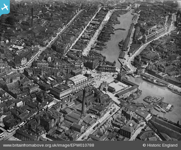
EPW010788 ENGLAND (1924). City Hall, Queen's Dock and environs, Kingston upon Hull, 1924. This image has been produced from a copy-negative.
    © Copyright OpenStreetMap contributors and licensed by the OpenStreetMap Foundation. 2025. Cartography is licensed as CC BY-SA.
  
Nearby Images (9)
Details
| Title | [EPW010788] City Hall, Queen's Dock and environs, Kingston upon Hull, 1924. This image has been produced from a copy-negative. | 
| Reference | EPW010788 | 
| Date | July-1924 | 
| Link | |
| Place name | KINGSTON UPON HULL | 
| Parish | |
| District | |
| Country | ENGLAND | 
| Easting / Northing | 509640, 428801 | 
| Longitude / Latitude | -0.33733188228979, 53.743819331255 | 
| National Grid Reference | TA096288 | 
Pins
|  Tram generating power station. |   John Wass | Friday 3rd of April 2015 09:04:30 PM | 
 
             
  ![[EPW010788] City Hall, Queen's Dock and environs, Kingston upon Hull, 1924. This image has been produced from a copy-negative.](http://britainfromabove.org.uk/sites/all/libraries/aerofilms-images/public/100x100/EPW/010/EPW010788.jpg) 
  
                                          ![[EPW012805] Queen Victoria Square, Kingston upon Hull, 1925](http://britainfromabove.org.uk/sites/all/libraries/aerofilms-images/public/100x100/EPW/012/EPW012805.jpg) 
 ![[EPW036496] Prince's Dockand environs, Kingston upon Hull, 1931](http://britainfromabove.org.uk/sites/all/libraries/aerofilms-images/public/100x100/EPW/036/EPW036496.jpg) 
 ![[EPW012693] City Hall and environs, Kingston upon Hull, 1925](http://britainfromabove.org.uk/sites/all/libraries/aerofilms-images/public/100x100/EPW/012/EPW012693.jpg) 
 ![[EPW036495] Ferens Art Gallery and Queen Victoria Square, Kingston upon Hull, 1931](http://britainfromabove.org.uk/sites/all/libraries/aerofilms-images/public/100x100/EPW/036/EPW036495.jpg) 
 ![[EPW036497] Whitefriargate Bridge and Queen Victoria Square, Kingston upon Hull, 1931](http://britainfromabove.org.uk/sites/all/libraries/aerofilms-images/public/100x100/EPW/036/EPW036497.jpg) 
 ![[EPW012811] The junction of Savile Street and George Street, Kingston upon Hull, 1925](http://britainfromabove.org.uk/sites/all/libraries/aerofilms-images/public/100x100/EPW/012/EPW012811.jpg) 
 ![[EAW015657] Humber Dock, the Old Harbour and city around Queen's Gardens, Kingston upon Hull, 1948. This image has been produced from a print.](http://britainfromabove.org.uk/sites/all/libraries/aerofilms-images/public/100x100/EAW/015/EAW015657.jpg) 
 ![[EPW010789] Holy Trinity Church and the surrounding area, Kingston upon Hull, 1924. This image has been produced from a copy-negative.](http://britainfromabove.org.uk/sites/all/libraries/aerofilms-images/public/100x100/EPW/010/EPW010789.jpg)