
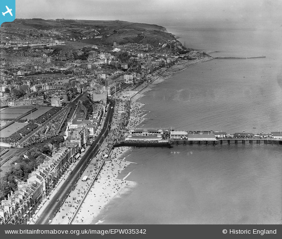
EPW035342 ENGLAND (1931). The pier and town, Hastings, from the west, 1931
© Copyright OpenStreetMap contributors and licensed by the OpenStreetMap Foundation. 2026. Cartography is licensed as CC BY-SA.
Nearby Images (23)
EPW035342

EAW002409

EPW035334

EPW039388

EAW002410

EPW026191

EPW026209

EPW026188

EAW022975

EPW000060B

EPW026200

EPW044648

EPW035339

EPW035346

EPW039390

EAW006619

EAW002411

EPW042840

EAW002408

EAW006618

EPW035345

EAW030089

EPW000754

Details
| Title | [EPW035342] The pier and town, Hastings, from the west, 1931 |
| Reference | EPW035342 |
| Date | 25-May-1931 |
| Link | |
| Place name | HASTINGS |
| Parish | |
| District | |
| Country | ENGLAND |
| Easting / Northing | 581056, 109038 |
| Longitude / Latitude | 0.57250566697079, 50.851922401661 |
| National Grid Reference | TQ811090 |
Pins

Alan McFaden |
Tuesday 8th of July 2014 10:51:31 AM | |

Jim |
Tuesday 14th of May 2013 05:21:18 PM | |
Although I now believe it is the later 130 foot octagonal "1870 Sewage Manure Work" chimney. The clubhouse of the Hastings Motorboat and Yacht Club now stands on the site. http://www.hastingschronicle.net/rock-a-noreEcoNore.html |
Jim |
Tuesday 14th of May 2013 05:25:45 PM |
