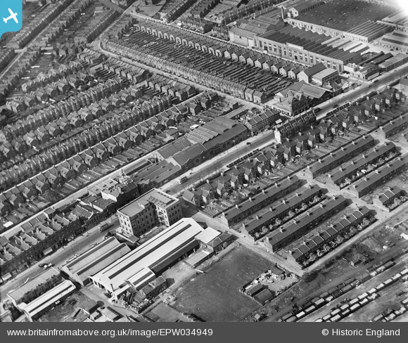
EPW034949 ENGLAND (1931). Mora Road, Edgware Road and environs, Cricklewood, 1931
© Copyright OpenStreetMap contributors and licensed by the OpenStreetMap Foundation. 2026. Cartography is licensed as CC BY-SA.
Nearby Images (33)
Details
| Title | [EPW034949] Mora Road, Edgware Road and environs, Cricklewood, 1931 |
| Reference | EPW034949 |
| Date | April-1931 |
| Link | |
| Place name | CRICKLEWOOD |
| Parish | |
| District | |
| Country | ENGLAND |
| Easting / Northing | 523593, 185967 |
| Longitude / Latitude | -0.21692630270682, 51.558549781105 |
| National Grid Reference | TQ236860 |
Pins

The Laird |
Saturday 3rd of October 2015 11:56:35 AM | |

Gladstone Hay |
Friday 29th of November 2013 07:29:09 PM | |

SF |
Monday 6th of May 2013 05:37:06 PM | |

SF |
Monday 6th of May 2013 05:35:59 PM |


![[EPW034949] Mora Road, Edgware Road and environs, Cricklewood, 1931](http://britainfromabove.org.uk/sites/all/libraries/aerofilms-images/public/100x100/EPW/034/EPW034949.jpg)
![[EPW034947] Rolls Razor Ltd and environs, Cricklewood, 1931](http://britainfromabove.org.uk/sites/all/libraries/aerofilms-images/public/100x100/EPW/034/EPW034947.jpg)
![[EAW048111] The Rolls Razor Factory, Cricklewood, 1952](http://britainfromabove.org.uk/sites/all/libraries/aerofilms-images/public/100x100/EAW/048/EAW048111.jpg)
![[EAW048107] The Rolls Razor Factory and environs, Cricklewood, 1952. This image was marked by Aerofilms Ltd for photo editing.](http://britainfromabove.org.uk/sites/all/libraries/aerofilms-images/public/100x100/EAW/048/EAW048107.jpg)
![[EAW048852] The Rolls Razor Factory and the surrounding residential area, Cricklewood, 1953. This image was marked by Aerofilms Ltd for photo editing.](http://britainfromabove.org.uk/sites/all/libraries/aerofilms-images/public/100x100/EAW/048/EAW048852.jpg)
![[EPW034952] The Edgware Road and environs, Cricklewood, 1931](http://britainfromabove.org.uk/sites/all/libraries/aerofilms-images/public/100x100/EPW/034/EPW034952.jpg)
![[EPW034946] The Edgware Road and environs, Cricklewood, 1931](http://britainfromabove.org.uk/sites/all/libraries/aerofilms-images/public/100x100/EPW/034/EPW034946.jpg)
![[EPW034950] The Edgware Road and environs, Cricklewood, 1931](http://britainfromabove.org.uk/sites/all/libraries/aerofilms-images/public/100x100/EPW/034/EPW034950.jpg)
![[EAW048112] The Rolls Razor Factory and environs, Cricklewood, 1952. This image was marked by Aerofilms Ltd for photo editing.](http://britainfromabove.org.uk/sites/all/libraries/aerofilms-images/public/100x100/EAW/048/EAW048112.jpg)
![[EAW048113] The Rolls Razor Factory, Cricklewood, 1952. This image was marked by Aerofilms Ltd for photo editing.](http://britainfromabove.org.uk/sites/all/libraries/aerofilms-images/public/100x100/EAW/048/EAW048113.jpg)
![[EAW048110] The Rolls Razor Factory, Cricklewood, 1952. This image was marked by Aerofilms Ltd for photo editing.](http://britainfromabove.org.uk/sites/all/libraries/aerofilms-images/public/100x100/EAW/048/EAW048110.jpg)
![[EAW049163] The Rolls Razor Factory, Cricklewood, 1953. This image was marked by Aerofilms Ltd for photo editing.](http://britainfromabove.org.uk/sites/all/libraries/aerofilms-images/public/100x100/EAW/049/EAW049163.jpg)
![[EAW048108] The Rolls Razor Factory, Cricklewood, 1952. This image was marked by Aerofilms Ltd for photo editing.](http://britainfromabove.org.uk/sites/all/libraries/aerofilms-images/public/100x100/EAW/048/EAW048108.jpg)
![[EPW034951] The Edgware Road and environs, Cricklewood, 1931](http://britainfromabove.org.uk/sites/all/libraries/aerofilms-images/public/100x100/EPW/034/EPW034951.jpg)
![[EPW034945] The Edgware Road and environs, Cricklewood, 1931](http://britainfromabove.org.uk/sites/all/libraries/aerofilms-images/public/100x100/EPW/034/EPW034945.jpg)
![[EAW048109] The Rolls Razor Factory, Cricklewood, 1952. This image was marked by Aerofilms Ltd for photo editing.](http://britainfromabove.org.uk/sites/all/libraries/aerofilms-images/public/100x100/EAW/048/EAW048109.jpg)
![[EAW048857] The Rolls Razor Factory off Cricklewood Broadway, Cricklewood, 1953. This image was marked by Aerofilms Ltd for photo editing.](http://britainfromabove.org.uk/sites/all/libraries/aerofilms-images/public/100x100/EAW/048/EAW048857.jpg)
![[EAW049165] The Rolls Razor Factory, Cricklewood, 1953. This image was marked by Aerofilms Ltd for photo editing.](http://britainfromabove.org.uk/sites/all/libraries/aerofilms-images/public/100x100/EAW/049/EAW049165.jpg)
![[EAW048858] The Rolls Razor Factory off Cricklewood Broadway, Cricklewood, 1953. This image was marked by Aerofilms Ltd for photo editing.](http://britainfromabove.org.uk/sites/all/libraries/aerofilms-images/public/100x100/EAW/048/EAW048858.jpg)
![[EAW049164] The Rolls Razor Factory, Cricklewood, 1953. This image was marked by Aerofilms Ltd for photo editing.](http://britainfromabove.org.uk/sites/all/libraries/aerofilms-images/public/100x100/EAW/049/EAW049164.jpg)
![[EAW020699] Golders Green and suburban north London, Cricklewood, from the south-west, 1948](http://britainfromabove.org.uk/sites/all/libraries/aerofilms-images/public/100x100/EAW/020/EAW020699.jpg)
![[EAW048856] The Rolls Razor Factory, Ashford Court and the surrounding residential area, Cricklewood, 1953. This image was marked by Aerofilms Ltd for photo editing.](http://britainfromabove.org.uk/sites/all/libraries/aerofilms-images/public/100x100/EAW/048/EAW048856.jpg)
![[EAW048854] The Rolls Razor Factory, Ashford Court and the surrounding residential area, Cricklewood, 1953. This image was marked by Aerofilms Ltd for photo editing.](http://britainfromabove.org.uk/sites/all/libraries/aerofilms-images/public/100x100/EAW/048/EAW048854.jpg)
![[EAW048855] The Rolls Razor Factory and the surrounding residential area, Cricklewood, 1953. This image was marked by Aerofilms Ltd for photo editing.](http://britainfromabove.org.uk/sites/all/libraries/aerofilms-images/public/100x100/EAW/048/EAW048855.jpg)
![[EAW048853] The Rolls Razor Factory and the surrounding residential area, Cricklewood, 1953](http://britainfromabove.org.uk/sites/all/libraries/aerofilms-images/public/100x100/EAW/048/EAW048853.jpg)
![[EPW025878] Stoll Studios, Smiths Clock Factory and environs, Cricklewood, 1929](http://britainfromabove.org.uk/sites/all/libraries/aerofilms-images/public/100x100/EPW/025/EPW025878.jpg)
![[EPW025880] Stoll Studios, Smiths Clock Factory and environs, Cricklewood, 1929](http://britainfromabove.org.uk/sites/all/libraries/aerofilms-images/public/100x100/EPW/025/EPW025880.jpg)
![[EPW025882] Stoll Studios, Smiths Clock Factory and environs, Cricklewood, 1929](http://britainfromabove.org.uk/sites/all/libraries/aerofilms-images/public/100x100/EPW/025/EPW025882.jpg)
![[EPW025879] Stoll Studios, Smiths Clock Factory and environs, Cricklewood, 1929](http://britainfromabove.org.uk/sites/all/libraries/aerofilms-images/public/100x100/EPW/025/EPW025879.jpg)
![[EPW005637] Stoll Film Studios and Smiths Clock Works, Cricklewood, 1921](http://britainfromabove.org.uk/sites/all/libraries/aerofilms-images/public/100x100/EPW/005/EPW005637.jpg)
![[EPW025874] Oaklands Road and environs, Cricklewood, 1929](http://britainfromabove.org.uk/sites/all/libraries/aerofilms-images/public/100x100/EPW/025/EPW025874.jpg)
![[EPW025877] Oaklands Road and environs, Cricklewood, 1929](http://britainfromabove.org.uk/sites/all/libraries/aerofilms-images/public/100x100/EPW/025/EPW025877.jpg)
![[EPW005653] Queen's Hall Cinema, Cricklewood, 1921. This image has been produced from a copy-negative.](http://britainfromabove.org.uk/sites/all/libraries/aerofilms-images/public/100x100/EPW/005/EPW005653.jpg)