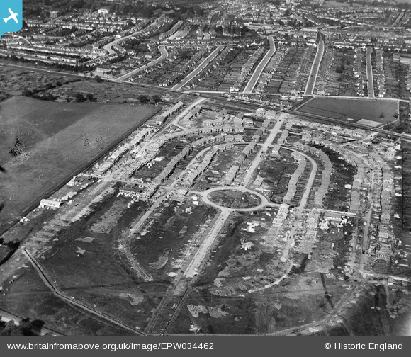
EPW034462 ENGLAND (1930). Housing under construction at Pennine Drive, Golders Green, 1930
© Copyright OpenStreetMap contributors and licensed by the OpenStreetMap Foundation. 2025. Cartography is licensed as CC BY-SA.
Nearby Images (12)
Details
| Title | [EPW034462] Housing under construction at Pennine Drive, Golders Green, 1930 |
| Reference | EPW034462 |
| Date | August-1930 |
| Link | |
| Place name | GOLDERS GREEN |
| Parish | |
| District | |
| Country | ENGLAND |
| Easting / Northing | 524009, 186884 |
| Longitude / Latitude | -0.21060425696778, 51.566700476024 |
| National Grid Reference | TQ240869 |
Pins
Be the first to add a comment to this image!


![[EPW034462] Housing under construction at Pennine Drive, Golders Green, 1930](http://britainfromabove.org.uk/sites/all/libraries/aerofilms-images/public/100x100/EPW/034/EPW034462.jpg)
![[EPW034463] Housing under construction at Pennine Drive and environs, Golders Green, 1930](http://britainfromabove.org.uk/sites/all/libraries/aerofilms-images/public/100x100/EPW/034/EPW034463.jpg)
![[EPW034470] Housing under construction at Pennine Drive, Golders Green, 1930](http://britainfromabove.org.uk/sites/all/libraries/aerofilms-images/public/100x100/EPW/034/EPW034470.jpg)
![[EPW034469] Housing under construction at Pennine Drive, Golders Green, 1930](http://britainfromabove.org.uk/sites/all/libraries/aerofilms-images/public/100x100/EPW/034/EPW034469.jpg)
![[EPW034464] Housing under construction at Pennine Drive and environs, Golders Green, 1930](http://britainfromabove.org.uk/sites/all/libraries/aerofilms-images/public/100x100/EPW/034/EPW034464.jpg)
![[EPW038718] Housing at Pennine Drive, Golders Green, 1932](http://britainfromabove.org.uk/sites/all/libraries/aerofilms-images/public/100x100/EPW/038/EPW038718.jpg)
![[EPW034466] Housing under construction at Pennine Drive, Golders Green, 1930](http://britainfromabove.org.uk/sites/all/libraries/aerofilms-images/public/100x100/EPW/034/EPW034466.jpg)
![[EPW034467] Housing under construction at Pennine Drive, Golders Green, 1930](http://britainfromabove.org.uk/sites/all/libraries/aerofilms-images/public/100x100/EPW/034/EPW034467.jpg)
![[EPW034468] Housing under construction at Pennine Drive, Golders Green, 1930](http://britainfromabove.org.uk/sites/all/libraries/aerofilms-images/public/100x100/EPW/034/EPW034468.jpg)
![[EPW034471] Housing under construction at Pennine Drive and environs, Golders Green, from the south-east, 1930](http://britainfromabove.org.uk/sites/all/libraries/aerofilms-images/public/100x100/EPW/034/EPW034471.jpg)
![[EPW034465] Housing under construction at Pennine Drive and environs, Golders Green, from the south-west, 1930](http://britainfromabove.org.uk/sites/all/libraries/aerofilms-images/public/100x100/EPW/034/EPW034465.jpg)
![[EPW052704] Pennine Drive, Hendon Way and environs, Golders Green, 1937. This image has been produced from a copy-negative.](http://britainfromabove.org.uk/sites/all/libraries/aerofilms-images/public/100x100/EPW/052/EPW052704.jpg)