
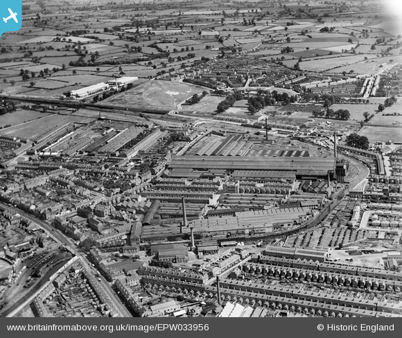
EPW033956 ENGLAND (1930). The English Electric Co Works, Coventry, 1930
© Copyright OpenStreetMap contributors and licensed by the OpenStreetMap Foundation. 2026. Cartography is licensed as CC BY-SA.
Nearby Images (12)
EPW033956

EPW033965

EPW001193

EPW033959

EPW033958

EPW010519

EPW010520

EPW033964

EPW061097

EPW061217

EPW010518

EPW033963

Details
| Title | [EPW033956] The English Electric Co Works, Coventry, 1930 |
| Reference | EPW033956 |
| Date | July-1930 |
| Link | |
| Place name | COVENTRY |
| Parish | |
| District | |
| Country | ENGLAND |
| Easting / Northing | 434619, 280319 |
| Longitude / Latitude | -1.4908999554248, 52.419390210945 |
| National Grid Reference | SP346803 |
Pins

PeteW |
Wednesday 11th of September 2019 12:21:44 PM | |
|
PeteW |
Wednesday 11th of September 2019 12:19:58 PM | |
|
PeteW |
Wednesday 11th of September 2019 12:17:39 PM | |
|
PeteW |
Wednesday 11th of September 2019 12:14:16 PM | |
|
PeteW |
Wednesday 11th of September 2019 12:13:22 PM | |
|
PeteW |
Wednesday 11th of September 2019 12:12:16 PM | |
|
PeteW |
Wednesday 11th of September 2019 12:11:05 PM | |
|
PeteW |
Wednesday 11th of September 2019 12:08:48 PM | |
|
Bob Curtis |
Friday 1st of April 2016 11:43:34 AM | |
|
Bob Curtis |
Friday 1st of April 2016 11:42:38 AM | |
|
Bob Curtis |
Friday 1st of April 2016 11:42:01 AM |
User Comment Contributions

Because of the occupation of the Ordnance Works by the Admiralty from 1938 this area suffered badly from the bombing |
Bob Curtis |
Monday 4th of April 2016 10:33:45 AM |