
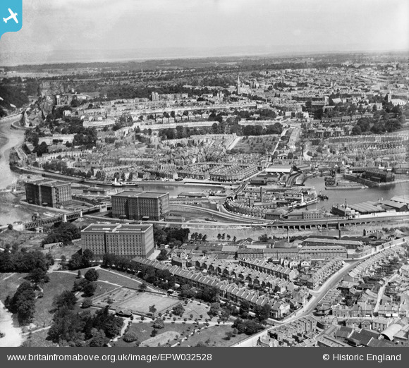
EPW032528 ENGLAND (1930). Greville Smyth Park, the Cumberland Basin and Clifton, Bristol, from the south, 1930
© Copyright OpenStreetMap contributors and licensed by the OpenStreetMap Foundation. 2026. Cartography is licensed as CC BY-SA.
Nearby Images (7)
EPW032528

EAW033324

EPW034461

EPW005479

EPW033497

EPW012016

EPW012015

Details
| Title | [EPW032528] Greville Smyth Park, the Cumberland Basin and Clifton, Bristol, from the south, 1930 |
| Reference | EPW032528 |
| Date | June-1930 |
| Link | |
| Place name | BRISTOL |
| Parish | |
| District | |
| Country | ENGLAND |
| Easting / Northing | 357097, 171920 |
| Longitude / Latitude | -2.6173930989498, 51.44415377769 |
| National Grid Reference | ST571719 |
Pins

Erik |
Sunday 26th of June 2022 09:02:08 AM | |
|
MB |
Thursday 29th of September 2016 05:06:29 PM | |
|
MB |
Thursday 29th of September 2016 05:04:35 PM | |
|
MB |
Thursday 29th of September 2016 05:03:59 PM | |
|
MB |
Thursday 29th of September 2016 05:03:11 PM | |
|
kevtees |
Friday 21st of February 2014 03:22:25 PM | |

Class31 |
Saturday 6th of April 2013 06:07:57 PM | |
|
Class31 |
Saturday 6th of April 2013 05:59:49 PM | |
|
Class31 |
Monday 18th of February 2013 11:48:43 PM | |
|
Class31 |
Monday 18th of February 2013 11:48:24 PM | |
|
Class31 |
Monday 18th of February 2013 11:47:49 PM | |
|
Class31 |
Monday 18th of February 2013 11:47:22 PM | |
|
Class31 |
Monday 18th of February 2013 11:46:47 PM | |
|
Class31 |
Monday 18th of February 2013 11:46:11 PM | |
|
Class31 |
Monday 18th of February 2013 11:45:24 PM | |
|
Class31 |
Monday 18th of February 2013 11:44:11 PM | |
|
Class31 |
Monday 18th of February 2013 11:43:27 PM | |
|
Class31 |
Monday 18th of February 2013 11:39:39 PM | |
|
Class31 |
Monday 18th of February 2013 11:39:07 PM | |
|
Class31 |
Monday 18th of February 2013 11:38:38 PM | |
|
Class31 |
Monday 18th of February 2013 11:38:13 PM | |
|
Class31 |
Monday 18th of February 2013 11:37:35 PM | |
|
Class31 |
Monday 18th of February 2013 11:36:57 PM | |
|
Class31 |
Monday 18th of February 2013 11:35:54 PM |
