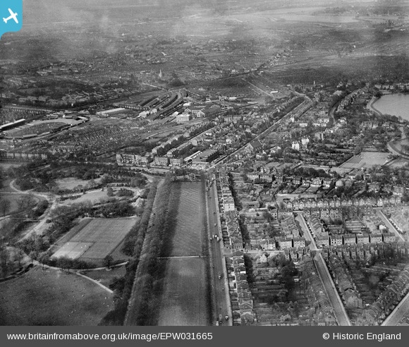
EPW031665 ENGLAND (1930). Finsbury Park and Seven Sisters Road, Finsbury Park, from the south-west, 1930
© Copyright OpenStreetMap contributors and licensed by the OpenStreetMap Foundation. 2026. Cartography is licensed as CC BY-SA.
Nearby Images (6)
Details
| Title | [EPW031665] Finsbury Park and Seven Sisters Road, Finsbury Park, from the south-west, 1930 |
| Reference | EPW031665 |
| Date | April-1930 |
| Link | |
| Place name | FINSBURY PARK |
| Parish | |
| District | |
| Country | ENGLAND |
| Easting / Northing | 531850, 187238 |
| Longitude / Latitude | -0.09739435074947, 51.568102903958 |
| National Grid Reference | TQ319872 |
Pins

billyfern |
Monday 30th of June 2014 12:09:14 AM | |

billyfern |
Monday 30th of June 2014 12:08:15 AM | |

billyfern |
Monday 30th of June 2014 12:07:28 AM | |

billyfern |
Monday 30th of June 2014 12:06:52 AM | |

billyfern |
Monday 30th of June 2014 12:06:32 AM | |

billyfern |
Monday 30th of June 2014 12:06:11 AM |


![[EPW031665] Finsbury Park and Seven Sisters Road, Finsbury Park, from the south-west, 1930](http://britainfromabove.org.uk/sites/all/libraries/aerofilms-images/public/100x100/EPW/031/EPW031665.jpg)
![[EPW031501] Finsbury Park, Woodberry Grove and environs, Finsbury Park, from the south-west, 1930](http://britainfromabove.org.uk/sites/all/libraries/aerofilms-images/public/100x100/EPW/031/EPW031501.jpg)
![[EPW031660] Finsbury Park and Seven Sisters Road, Finsbury Park, from the south-west, 1930](http://britainfromabove.org.uk/sites/all/libraries/aerofilms-images/public/100x100/EPW/031/EPW031660.jpg)
![[EPW031504] Finsbury Park, Woodberry Grove and Harringay Stadium, Finsbury Park, from the south-west, 1930](http://britainfromabove.org.uk/sites/all/libraries/aerofilms-images/public/100x100/EPW/031/EPW031504.jpg)
![[EPW031663] Finsbury Park and Seven Sisters Road, Finsbury Park, from the south-west, 1930](http://britainfromabove.org.uk/sites/all/libraries/aerofilms-images/public/100x100/EPW/031/EPW031663.jpg)
![[EPW031507] The Metropolitan Water Board Filter Beds, terraced housing off Gloucester Road and Finsbury Park, Stoke Newington, from the south, 1930](http://britainfromabove.org.uk/sites/all/libraries/aerofilms-images/public/100x100/EPW/031/EPW031507.jpg)