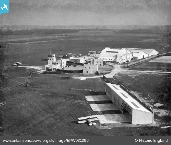
EPW031396 ENGLAND (1930). Heston Air Park, Heston, 1930. This image has been produced from a print.
© Copyright OpenStreetMap contributors and licensed by the OpenStreetMap Foundation. 2026. Cartography is licensed as CC BY-SA.
Nearby Images (48)
Details
| Title | [EPW031396] Heston Air Park, Heston, 1930. This image has been produced from a print. |
| Reference | EPW031396 |
| Date | February-1930 |
| Link | |
| Place name | HESTON |
| Parish | |
| District | |
| Country | ENGLAND |
| Easting / Northing | 511206, 177659 |
| Longitude / Latitude | -0.39817672397306, 51.486448384968 |
| National Grid Reference | TQ112777 |
Pins

clippedwings |
Wednesday 14th of January 2015 09:15:06 PM |


![[EPW031396] Heston Air Park, Heston, 1930. This image has been produced from a print.](http://britainfromabove.org.uk/sites/all/libraries/aerofilms-images/public/100x100/EPW/031/EPW031396.jpg)
![[EPW037941] Heston, Household Brigade Flying Club Meeting at Heston Airport, 1932](http://britainfromabove.org.uk/sites/all/libraries/aerofilms-images/public/100x100/EPW/037/EPW037941.jpg)
![[EPW036080] Heston, the Household Brigade Flying Club meeting at Heston Air Park, 1931](http://britainfromabove.org.uk/sites/all/libraries/aerofilms-images/public/100x100/EPW/036/EPW036080.jpg)
![[EPW060375] Hangars and terminal buildings at Heston Airport, Heston, from the north-west, 1939](http://britainfromabove.org.uk/sites/all/libraries/aerofilms-images/public/100x100/EPW/060/EPW060375.jpg)
![[EPW033759] Heston Air Park, Heston, from the south-west, 1930](http://britainfromabove.org.uk/sites/all/libraries/aerofilms-images/public/100x100/EPW/033/EPW033759.jpg)
![[EPW041419] Aircraft assembled for the second Morning Post Cross-Country Air Race, Heston, from the west, 1933](http://britainfromabove.org.uk/sites/all/libraries/aerofilms-images/public/100x100/EPW/041/EPW041419.jpg)
![[EPW037901] Heston, Household Brigade Flying Club Meeting at Heston Airport, 1932](http://britainfromabove.org.uk/sites/all/libraries/aerofilms-images/public/100x100/EPW/037/EPW037901.jpg)
![[EPW037902] Heston, Household Brigade Flying Club Meeting at Heston Airport, 1932](http://britainfromabove.org.uk/sites/all/libraries/aerofilms-images/public/100x100/EPW/037/EPW037902.jpg)
![[EPW060377] Hangars and terminal buildings at Heston Airport, Heston, 1939](http://britainfromabove.org.uk/sites/all/libraries/aerofilms-images/public/100x100/EPW/060/EPW060377.jpg)
![[EPW031394] Heston Air Park, Heston, from the west, 1930](http://britainfromabove.org.uk/sites/all/libraries/aerofilms-images/public/100x100/EPW/031/EPW031394.jpg)
![[EPW038204] Handley Page HP.42W Western 42/5 G-AAXD "Horatius" and other aircraft at Heston Aerodrome, Heston, 1932](http://britainfromabove.org.uk/sites/all/libraries/aerofilms-images/public/100x100/EPW/038/EPW038204.jpg)
![[EPW038205] Handley Page HP.42W Western 42/5 G-AAXD "Horatius" and other aircraft at Heston Aerodrome, Heston, 1932](http://britainfromabove.org.uk/sites/all/libraries/aerofilms-images/public/100x100/EPW/038/EPW038205.jpg)
![[EPW036120] Heston, the King's Cup Race competitors' aircraft assembled on the airfield, 1931](http://britainfromabove.org.uk/sites/all/libraries/aerofilms-images/public/100x100/EPW/036/EPW036120.jpg)
![[EPW031397] Heston Air Park, Heston, from the south-west, 1930](http://britainfromabove.org.uk/sites/all/libraries/aerofilms-images/public/100x100/EPW/031/EPW031397.jpg)
![[EPW053980] Heston Aerodrome, Heston, 1937](http://britainfromabove.org.uk/sites/all/libraries/aerofilms-images/public/100x100/EPW/053/EPW053980.jpg)
![[EPW044699] Customs House, hangars and aircraft at Heston Aerodrome, Heston, 1934](http://britainfromabove.org.uk/sites/all/libraries/aerofilms-images/public/100x100/EPW/044/EPW044699.jpg)
![[EPW037936] Heston, Household Brigade Flying Club Meeting at Heston Airport, 1932](http://britainfromabove.org.uk/sites/all/libraries/aerofilms-images/public/100x100/EPW/037/EPW037936.jpg)
![[EPW037938] Heston, Household Brigade Flying Club Meeting at Heston Airport, 1932](http://britainfromabove.org.uk/sites/all/libraries/aerofilms-images/public/100x100/EPW/037/EPW037938.jpg)
![[EPW036079] Heston, the Household Brigade Flying Club meeting at Heston Air Park, 1931](http://britainfromabove.org.uk/sites/all/libraries/aerofilms-images/public/100x100/EPW/036/EPW036079.jpg)
![[EPW031395] Heston Air Park, Heston, 1930](http://britainfromabove.org.uk/sites/all/libraries/aerofilms-images/public/100x100/EPW/031/EPW031395.jpg)
![[EPW037933] Heston, Household Brigade Flying Club Meeting at Heston Airport, 1932](http://britainfromabove.org.uk/sites/all/libraries/aerofilms-images/public/100x100/EPW/037/EPW037933.jpg)
![[EPW040090] Heston Airport, Heston, 1932. This image was marked by Aerofilms Ltd for photo editing.](http://britainfromabove.org.uk/sites/all/libraries/aerofilms-images/public/100x100/EPW/040/EPW040090.jpg)
![[EPW028592] The Heston Air Park and environs, Heston, 1929](http://britainfromabove.org.uk/sites/all/libraries/aerofilms-images/public/100x100/EPW/028/EPW028592.jpg)
![[EPW038201] Handley Page HP.42W Western 42/5 G-AAXD "Horatius" and other aircraft at Heston Aerodrome, Heston, 1932](http://britainfromabove.org.uk/sites/all/libraries/aerofilms-images/public/100x100/EPW/038/EPW038201.jpg)
![[EPW040089] Heston Airport, Heston, 1932](http://britainfromabove.org.uk/sites/all/libraries/aerofilms-images/public/100x100/EPW/040/EPW040089.jpg)
![[EPW038207] Handley Page HP.42W Western 42/5 G-AAXD "Horatius" and other aircraft at Heston Aerodrome, Heston, 1932](http://britainfromabove.org.uk/sites/all/libraries/aerofilms-images/public/100x100/EPW/038/EPW038207.jpg)
![[EPW044693] Customs House, hangars and aircraft at Heston Aerodrome, Heston, 1934](http://britainfromabove.org.uk/sites/all/libraries/aerofilms-images/public/100x100/EPW/044/EPW044693.jpg)
![[EPW028210] Heston, Aerial Garden Party at Heston Air Park, 1929](http://britainfromabove.org.uk/sites/all/libraries/aerofilms-images/public/100x100/EPW/028/EPW028210.jpg)
![[EPW028591] The Heston Air Park, Heston, 1929](http://britainfromabove.org.uk/sites/all/libraries/aerofilms-images/public/100x100/EPW/028/EPW028591.jpg)
![[EPW033771] Hangars and planes at Heston Air Park, Heston, 1930](http://britainfromabove.org.uk/sites/all/libraries/aerofilms-images/public/100x100/EPW/033/EPW033771.jpg)
![[EPW037937] Heston, Household Brigade Flying Club Meeting at Heston Airport, 1932](http://britainfromabove.org.uk/sites/all/libraries/aerofilms-images/public/100x100/EPW/037/EPW037937.jpg)
![[EPW036078] Heston, the Household Brigade Flying Club meeting at Heston Air Park, 1931](http://britainfromabove.org.uk/sites/all/libraries/aerofilms-images/public/100x100/EPW/036/EPW036078.jpg)
![[EPW037522] Heston Airport buildings with De Havilland DH60G "Gipsy Moth" aircraft G-ABEO on the airfield, Heston, 1932](http://britainfromabove.org.uk/sites/all/libraries/aerofilms-images/public/100x100/EPW/037/EPW037522.jpg)
![[EPW041420] Aircraft assembled for the second Morning Post Cross-Country Air Race, Heston, from the south-west, 1933](http://britainfromabove.org.uk/sites/all/libraries/aerofilms-images/public/100x100/EPW/041/EPW041420.jpg)
![[EPW031393] The Heston Air Park Customs House, Heston, 1930](http://britainfromabove.org.uk/sites/all/libraries/aerofilms-images/public/100x100/EPW/031/EPW031393.jpg)
![[EPW037586] Heston Airport buildings, Heston, 1932](http://britainfromabove.org.uk/sites/all/libraries/aerofilms-images/public/100x100/EPW/037/EPW037586.jpg)
![[EPW037338] Heston Airport, Heston, from the south-west, 1932](http://britainfromabove.org.uk/sites/all/libraries/aerofilms-images/public/100x100/EPW/037/EPW037338.jpg)
![[EPW061093] Heston Airport, Heston, 1939](http://britainfromabove.org.uk/sites/all/libraries/aerofilms-images/public/100x100/EPW/061/EPW061093.jpg)
![[EPW028213] Heston, Aerial Garden Party at Heston Air Park, 1929](http://britainfromabove.org.uk/sites/all/libraries/aerofilms-images/public/100x100/EPW/028/EPW028213.jpg)
![[EPW025552] The site of Heston Aerodrome, Heston, 1928. This image has been produced from a print.](http://britainfromabove.org.uk/sites/all/libraries/aerofilms-images/public/100x100/EPW/025/EPW025552.jpg)
![[EPW037989] Heston, aircraft lined up for the start of The Morning Post Cross-Country Air Race at Heston Aerodrome, from the south, 1932](http://britainfromabove.org.uk/sites/all/libraries/aerofilms-images/public/100x100/EPW/037/EPW037989.jpg)
![[EPW033767] Heston Air Park, Heston, from the north, 1930](http://britainfromabove.org.uk/sites/all/libraries/aerofilms-images/public/100x100/EPW/033/EPW033767.jpg)
![[EPW037940] Heston, Household Brigade Flying Club Meeting at Heston Airport, 1932](http://britainfromabove.org.uk/sites/all/libraries/aerofilms-images/public/100x100/EPW/037/EPW037940.jpg)
![[EPW037939] Heston, Household Brigade Flying Club Meeting at Heston Airport, 1932](http://britainfromabove.org.uk/sites/all/libraries/aerofilms-images/public/100x100/EPW/037/EPW037939.jpg)
![[EPW034901] DH60G Gipsy Moth G-AAKE flying above Heston Air Park, Heston, 1931](http://britainfromabove.org.uk/sites/all/libraries/aerofilms-images/public/100x100/EPW/034/EPW034901.jpg)
![[EPW037993] Heston, aircraft lined up for the start of The Morning Post Cross-Country Air Race at Heston Aerodrome, from the north-west, 1932](http://britainfromabove.org.uk/sites/all/libraries/aerofilms-images/public/100x100/EPW/037/EPW037993.jpg)
![[EPW037992] Heston, aircraft lined up for the start of The Morning Post Cross-Country Air Race at Heston Aerodrome, from the north-west, 1932](http://britainfromabove.org.uk/sites/all/libraries/aerofilms-images/public/100x100/EPW/037/EPW037992.jpg)
![[EPW060378] Heston Airport, Heston, 1939](http://britainfromabove.org.uk/sites/all/libraries/aerofilms-images/public/100x100/EPW/060/EPW060378.jpg)