
EPW026655 ENGLAND (1929). New housing at Deneside, Seaham, 1929
© Copyright OpenStreetMap contributors and licensed by the OpenStreetMap Foundation. 2026. Cartography is licensed as CC BY-SA.
Nearby Images (2)
EPW026655

EPW045932

Details
| Title | [EPW026655] New housing at Deneside, Seaham, 1929 |
| Reference | EPW026655 |
| Date | May-1929 |
| Link | |
| Place name | SEAHAM |
| Parish | SEAHAM |
| District | |
| Country | ENGLAND |
| Easting / Northing | 441727, 549233 |
| Longitude / Latitude | -1.3502731180908, 54.836088598516 |
| National Grid Reference | NZ417492 |
Pins

John Swain |
Thursday 8th of August 2013 04:40:26 PM | |
|
John Swain |
Wednesday 7th of August 2013 06:50:52 PM | |
|
John Swain |
Wednesday 7th of August 2013 06:47:45 PM | |
|
John Swain |
Wednesday 7th of August 2013 06:45:50 PM | |
|
John Swain |
Wednesday 7th of August 2013 06:44:58 PM | |
|
John Swain |
Wednesday 7th of August 2013 06:44:01 PM | |
|
John Swain |
Wednesday 7th of August 2013 06:42:07 PM | |
|
John Swain |
Wednesday 7th of August 2013 06:40:56 PM | |
|
John Swain |
Wednesday 7th of August 2013 06:38:40 PM | |
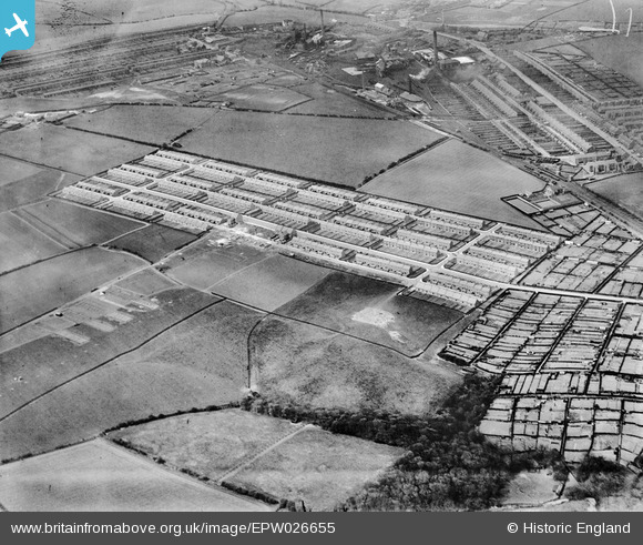
These streets were demolished after World War II, to be replaced with both council and privately-owned properties in Westlea and Eastlea, either side of the Stockton Road (B 1285). |
John Swain |
Thursday 8th of August 2013 04:46:42 PM |

Class31 |
Sunday 26th of May 2013 04:33:17 PM | |
|
Class31 |
Sunday 26th of May 2013 04:29:33 PM | |
|
Class31 |
Sunday 26th of May 2013 04:27:54 PM | |
Seaham Colliery closed in 1987 and the site is now largely vacant and fenced off, with the exception of the small Kingfisher Industrial Estate, and is awaiting a property developer to materialise in more economically prosperous times. Elsewhere in the town, the last pit to close, Vane Tempest in 1992, is now the site of the popular housing estate East Shore Village. |
John Swain |
Thursday 8th of August 2013 05:42:15 PM |
User Comment Contributions

The new council housing development at Deneside was completed by 1936, as shown in this large-scale plan from 1939. Most of the housing is extant in 2013, but the majority of the terraced streets on the north and west sides of the 1849-1987 Seaham Colliery have been demolished in the postwar period. |
John Swain |
Saturday 10th of August 2013 08:47:12 AM |
The Old People's Homes at The Lawns were built by the Council in 1933 and were demolished about 70 years later. On the map, they may be located south of The Avenue and west of the school, in a double, symmetrical, curvilinear pattern. |
John Swain |
Saturday 10th of August 2013 08:47:12 AM |

Station Road, formerly known as the Londonderry Road on older maps, former an important link between the coast road and what eventually became the A19. Hitherto, at least until the close of the 19th century, Seaham's main links were by railway. Some of the older Victorian terraced streets have long since disappeared, but a flavour of the building heritage of the area to the west of Seaham Harbour Station may be gleaned from the accompanying photograph taken on the afternoon of August 8, 2013. |
John Swain |
Thursday 8th of August 2013 05:34:42 PM |

It would be fascinating to see the development of this area with a later image from the Aerofilms Archives, say from the late 1930s, to show the emergence of a compact, not quite self-contained, estate of over 6,000 inhabitants, most of whom were housed in modern terraces and bungalows. However, road links with the main town of Seaham Harbour, and further afield to Sunderland and Hartlepool, remained poor until after World War II. |
John Swain |
Thursday 8th of August 2013 05:23:40 PM |
Hi John, Unfortunately this glass plate was a singleton. The image was shot amongst others in Durham and Newcastle, but there was just the one I'm afraid and from the Register entries it looks like the company didn't return until much later in the twentieth-century. I hope to be pleasantly surprised (their early record-keeping wasn't great, so the lack of the placename "Seaham" in the Registers doesn't mean for definite that images aren't there). Yours, Katy Britain from Above Cataloguing Team Leader |
Katy Whitaker |
Thursday 8th of August 2013 05:23:40 PM |

Between 1926 and 1936, 6,700 people were housed in Seaham Harbour Urban District Council properties on what was known, in the early stages, as the Carr House Estate, named after the local farm. After 1931, this was changed to Deneside. The Avenue was the first road to be laid out in 1926 and it still forms a main axis route into the town. This image shows the immediate developments on both sides of The Avenue and, following the 1930 Slum Clearance Act, rapid construction took place to create "Mushroom Town Marvel", as 3,300 folk were re-housed in Malvern and Ryton Crescents as well as south of Dalton Avenue (1929) to Kingston Avenue (1934). Shops, churches and schools were built by 1937. The George Inn on The Avenue opened for business in 1936 and there was provision for 150 old people in a small housing project called The Lawns, completed in 1933. The Deneside Estate has stood the test of time exceedingly well and most of the former council properties are now in private ownership. |
John Swain |
Thursday 8th of August 2013 05:04:35 PM |
Seaham grew as a coal-exporting port during the Victorian era from the 1830s and development continued with the opening of local collieries in 1849 (Seaham), 1899 (Dawdon) and 1928 (Vane Tempest). The town effectively expanded with both the harbour and the improving network of railways, and is often cited as an example of a 19th century "New Town". The period up to the beginning of the Great War in August 1914 is often referred to as a boom time in Seaham's fortunes, with a growth in population from 10,000 in 1901 to 11,000 ten years later. Apart from the colliery and the terraced rows in the top left (north-west) corner of the picture, Deneside represents some of the Interwar aspects, when all three collieries in the area were working and coal exports were at an all-time high, prior to the Depression years of the 1930s. Slum clearance areas elsewhere in the town were soon to be replaced with the new, lower density housing at Deneside, and there was further council house building schemes at Parkside, Eastlea, Westlea, Dene House Road and Northlea. Private houses were also constructed in theses areas, which continued well into the 1950s and 1960s. |
John Swain |
Thursday 8th of August 2013 04:43:02 PM |
The population of Seaham was 15,000 in 1911, and remained fairly steady to its current level a century later of 21,500. |
John Swain |
Thursday 8th of August 2013 04:43:02 PM |