
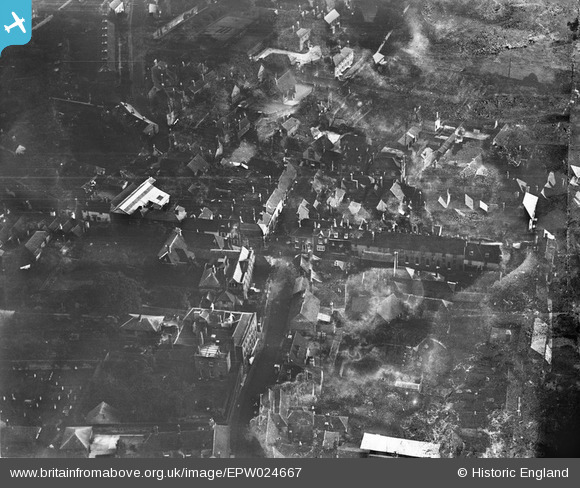
EPW024667 ENGLAND (1928). East Street and Middle Street, Petworth, 1928
© Copyright OpenStreetMap contributors and licensed by the OpenStreetMap Foundation. 2026. Cartography is licensed as CC BY-SA.
Nearby Images (5)
EPW024667

EPW024665

EPW024664

EPW024660

EPW024668

Details
| Title | [EPW024667] East Street and Middle Street, Petworth, 1928 |
| Reference | EPW024667 |
| Date | September-1928 |
| Link | |
| Place name | PETWORTH |
| Parish | PETWORTH |
| District | |
| Country | ENGLAND |
| Easting / Northing | 497762, 121656 |
| Longitude / Latitude | -0.60704912448863, 50.985453571035 |
| National Grid Reference | SU978217 |
Pins

Stephen Mirrington |
Tuesday 22nd of June 2021 11:12:23 AM | |
|
David960 |
Monday 26th of January 2015 06:54:12 PM | |
|
David960 |
Monday 26th of January 2015 06:54:12 PM | |
|
David960 |
Monday 26th of January 2015 06:51:21 PM | |
|
David960 |
Monday 26th of January 2015 06:50:42 PM | |
|
David960 |
Monday 26th of January 2015 06:47:01 PM | |
|
David960 |
Monday 26th of January 2015 06:44:34 PM | |
|
David960 |
Monday 26th of January 2015 06:43:21 PM | |
|
David960 |
Monday 26th of January 2015 06:42:27 PM | |
|
David960 |
Monday 26th of January 2015 06:42:08 PM |
User Comment Contributions

Several ex-pubs in Petworth are visible here: the Angel Shades, Red Lion, White Hart and Queen's Head. |
David960 |
Monday 26th of January 2015 06:48:51 PM |

Petworth United Reformed Church |

Alan McFaden |
Wednesday 10th of September 2014 10:24:19 AM |

Petworth |
Alan McFaden |
Wednesday 10th of September 2014 10:23:47 AM |

Petworth |
Alan McFaden |
Wednesday 10th of September 2014 10:23:30 AM |

Petworth |
Alan McFaden |
Wednesday 10th of September 2014 10:23:15 AM |