
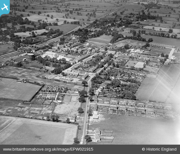
EPW021915 ENGLAND (1928). Borehamwood and environs, Borehamwood, 1928
© Copyright OpenStreetMap contributors and licensed by the OpenStreetMap Foundation. 2026. Cartography is licensed as CC BY-SA.
Nearby Images (6)
EPW021915

EPW021916

EAW041457

EPW025491

EAW044301

EAW041454

Details
| Title | [EPW021915] Borehamwood and environs, Borehamwood, 1928 |
| Reference | EPW021915 |
| Date | July-1928 |
| Link | |
| Place name | BOREHAMWOOD |
| Parish | ELSTREE AND BOREHAMWOOD |
| District | |
| Country | ENGLAND |
| Easting / Northing | 519439, 196351 |
| Longitude / Latitude | -0.27328838470616, 51.652779013128 |
| National Grid Reference | TQ194964 |
Pins

Brian |
Wednesday 27th of May 2020 09:48:53 PM | |
|
Brian |
Wednesday 27th of May 2020 09:45:49 PM | |
|
Brian |
Wednesday 27th of May 2020 09:44:53 PM | |
|
Brian |
Wednesday 27th of May 2020 09:43:56 PM | |
|
Brian |
Wednesday 27th of May 2020 09:41:48 PM | |
|
Brian |
Wednesday 27th of May 2020 09:40:19 PM | |
|
Rebecca |
Friday 11th of January 2013 06:10:49 PM | |
|
iantresman |
Tuesday 26th of June 2012 10:42:33 AM | |
|
iantresman |
Tuesday 26th of June 2012 10:41:10 AM | |
|
iantresman |
Tuesday 26th of June 2012 10:40:22 AM | |
|
iantresman |
Tuesday 26th of June 2012 10:39:14 AM | |
|
iantresman |
Tuesday 26th of June 2012 10:38:34 AM | |
|
iantresman |
Tuesday 26th of June 2012 10:37:36 AM | |
|
iantresman |
Tuesday 26th of June 2012 10:36:40 AM |
User Comment Contributions
The road beneath the plane is Furzehill Road and the view looks north. The station is beside the railway bridge on the left of the image. |
Scott Hatton |
Monday 25th of June 2012 03:33:23 PM |