
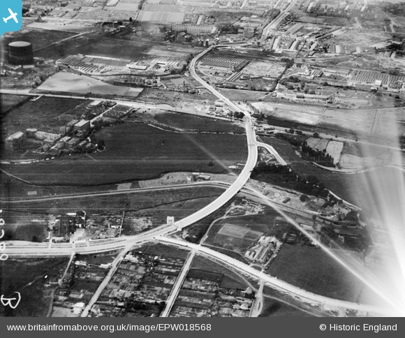
EPW018568 ENGLAND (1927). The Lea Valley Viaduct and environs, Chingford, 1927
© Copyright OpenStreetMap contributors and licensed by the OpenStreetMap Foundation. 2026. Cartography is licensed as CC BY-SA.
Nearby Images (21)
EPW018568

EPW053837

EPW056818

EPW018572

EPW018561

EPW018562

EPW052272

EPW052282

EPW018563

EPW049529

EPW018569

EPW056816

EPW056321

EPW053853

EPW056823

EPW018567

EPW018564

EPW052271

EPW018565

EPW049703

EPW018656

Details
| Title | [EPW018568] The Lea Valley Viaduct and environs, Chingford, 1927 |
| Reference | EPW018568 |
| Date | June-1927 |
| Link | |
| Place name | CHINGFORD |
| Parish | |
| District | |
| Country | ENGLAND |
| Easting / Northing | 536131, 192172 |
| Longitude / Latitude | -0.033743600197966, 51.611427699587 |
| National Grid Reference | TQ361922 |
Pins
Be the first to add a comment to this image!
User Comment Contributions
Settlements, industry, roads, canals and railways often follow river valleys as here. River valleys are flat and can be wide. Early settlements used rivers for transport and for water supplies. River valleys also provided fertile land for growing crops. |

MM |
Friday 5th of April 2013 01:23:32 PM |
Where best to start with this highly useful set of images showing the creation of the A406 North Circular Road? The benchmark from 018568 is from the lower left corner (from Walthamstow Crooked Billet direction. The beginnings of the London Rubber Company just border the left side of the road before the set of abutments. LRC building demolished 2002 & replaced by Costco.(They made Durex products of course and also manufactured Galloways Cough Mixture:hence "London E4" on labelling) The roads at the bottom are from L>R Westward Road & Sinclair Road. From the right the road joining is Hall Lane with the Cork Factory just beginning to be developed, further to the lower right is Chingford Pumping Station(now being squatted!) with the white highway behind it & better viewed in other images, is Lower Hall Lane. Worthy of note in that location is the small bridge which carries that road over a small stream, has fixed to one side of the parapet an ancient highway notice regarding weight limit of 'Locomotives' ie steam powered vehicles. Nobody has yet pinched that artifact! I will try to load up an image of that soon. As the road heads off in the distance (west) it crosses the River Lea centre of image, to the right at that point now is the Edmonton Incineration Plant. Beyond that and still on the right are factory sheds in abundance, whilst on the left is the Willoughby Road gasworks. Then the road climbs upwards and over the Hertford railway line (Angel Road Station just detectable to the right of the road). Sadly it is too far distant to pick out the railway sidings alongside Montagu Road and the place a little way further along that happened to be the birthplace of Bruce Forsyth Johnson (Sir Bruce Forsyth). I was recently informed by an elderly neighbour, at a time when the abutments at Cooks Ferry(they don't yet show up in these 1927 images) were being demolished for a roundabout (2003), that one of them carried an inscription picked out in the brickwork mentioning the construction date & architect? I hope someone might have taken a photograph at some time & load it up here. |
 8-2007.JPG)
Keith |
Sunday 1st of July 2012 01:02:19 AM |