
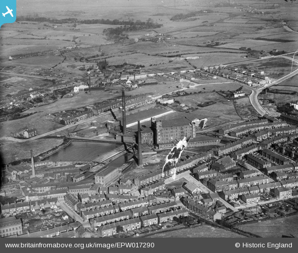
EPW017290 ENGLAND (1926). The Cromer Cotton Mill and environs, Middleton, 1926
© Copyright OpenStreetMap contributors and licensed by the OpenStreetMap Foundation. 2026. Cartography is licensed as CC BY-SA.
Nearby Images (11)
EPW017290

EAW041916

EAW041918

EAW041922

EAW041913

EAW041920

EAW041919

EAW041917

EAW041921

EAW041915

EAW041914

Details
| Title | [EPW017290] The Cromer Cotton Mill and environs, Middleton, 1926 |
| Reference | EPW017290 |
| Date | October-1926 |
| Link | |
| Place name | MIDDLETON |
| Parish | |
| District | |
| Country | ENGLAND |
| Easting / Northing | 387704, 406302 |
| Longitude / Latitude | -2.1856184941069, 53.552959300246 |
| National Grid Reference | SD877063 |
Pins

Rhodes Village |
Saturday 15th of June 2013 05:25:33 AM | |
|
Geoff Wellens |
Friday 19th of October 2012 07:48:54 PM | |
|
Geoff Wellens |
Friday 19th of October 2012 07:45:46 PM | |
|
Geoff Wellens |
Friday 19th of October 2012 07:45:08 PM | |
|
Geoff Wellens |
Friday 19th of October 2012 07:43:01 PM | |
|
Geoff Wellens |
Friday 19th of October 2012 07:39:59 PM | |
|
Geoff Wellens |
Friday 19th of October 2012 07:38:16 PM | |
|
Moonraker2 |
Friday 17th of August 2012 12:04:04 AM | |
|
Moonraker2 |
Friday 17th of August 2012 12:03:17 AM | |
|
Moonraker2 |
Friday 17th of August 2012 12:02:37 AM | |
|
Moonraker2 |
Friday 17th of August 2012 12:00:06 AM |
