
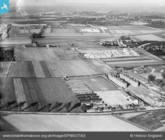
EPW017163 ENGLAND (1926). The Hounslow Barracks and new housing at Francis Road and environs, Hounslow, from the south-west, 1926
© Copyright OpenStreetMap contributors and licensed by the OpenStreetMap Foundation. 2026. Cartography is licensed as CC BY-SA.
Nearby Images (3)
EPW017163

EPW017160

EPW023228

Details
| Title | [EPW017163] The Hounslow Barracks and new housing at Francis Road and environs, Hounslow, from the south-west, 1926 |
| Reference | EPW017163 |
| Date | October-1926 |
| Link | |
| Place name | HOUNSLOW |
| Parish | |
| District | |
| Country | ENGLAND |
| Easting / Northing | 511648, 175526 |
| Longitude / Latitude | -0.39248708416389, 51.467187741763 |
| National Grid Reference | TQ116755 |
Pins

Flyerguilf |
Sunday 29th of June 2014 06:57:48 PM | |

Class31 |
Wednesday 2nd of April 2014 09:41:38 AM | |
|
Class31 |
Wednesday 2nd of April 2014 09:39:41 AM | |
 |
Class31 |
Wednesday 2nd of April 2014 09:39:15 AM |
|
local historian |
Wednesday 29th of May 2013 02:30:56 PM | |
|
local historian |
Wednesday 29th of May 2013 02:30:07 PM | |
|
local historian |
Wednesday 29th of May 2013 02:27:56 PM | |
|
local historian |
Wednesday 29th of May 2013 02:27:25 PM | |
|
local historian |
Wednesday 29th of May 2013 02:26:42 PM | |
|
local historian |
Wednesday 29th of May 2013 02:25:02 PM | |
|
local historian |
Wednesday 29th of May 2013 02:23:19 PM | |
|
local historian |
Wednesday 29th of May 2013 02:22:19 PM | |
|
local historian |
Wednesday 29th of May 2013 02:21:37 PM | |
|
local historian |
Wednesday 29th of May 2013 02:20:56 PM | |
|
local historian |
Wednesday 29th of May 2013 02:19:40 PM | |
|
local historian |
Wednesday 29th of May 2013 02:19:01 PM | |
|
local historian |
Wednesday 29th of May 2013 02:17:38 PM | |
|
APR |
Friday 16th of November 2012 02:09:59 PM |
