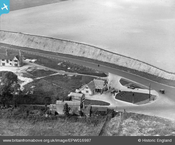
EPW016987 ENGLAND (1926). The newly-built bypass (A20) and petrol station, Farningham, 1926
© Copyright OpenStreetMap contributors and licensed by the OpenStreetMap Foundation. 2026. Cartography is licensed as CC BY-SA.
Nearby Images (15)
Details
| Title | [EPW016987] The newly-built bypass (A20) and petrol station, Farningham, 1926 |
| Reference | EPW016987 |
| Date | October-1926 |
| Link | |
| Place name | FARNINGHAM |
| Parish | FARNINGHAM |
| District | |
| Country | ENGLAND |
| Easting / Northing | 554646, 167264 |
| Longitude / Latitude | 0.22256195526909, 51.38283006304 |
| National Grid Reference | TQ546673 |
Pins
Be the first to add a comment to this image!


![[EPW016987] The newly-built bypass (A20) and petrol station, Farningham, 1926](http://britainfromabove.org.uk/sites/all/libraries/aerofilms-images/public/100x100/EPW/016/EPW016987.jpg)
![[EPW016852] Farningham Service Station, Farningham, 1926](http://britainfromabove.org.uk/sites/all/libraries/aerofilms-images/public/100x100/EPW/016/EPW016852.jpg)
![[EPW016984] The newly-built bypass (A20) and petrol station, Farningham, 1926](http://britainfromabove.org.uk/sites/all/libraries/aerofilms-images/public/100x100/EPW/016/EPW016984.jpg)
![[EPW016849] Farningham Service Station and environs, Farningham, 1926](http://britainfromabove.org.uk/sites/all/libraries/aerofilms-images/public/100x100/EPW/016/EPW016849.jpg)
![[EPW016848] Farningham Service Station and environs, Farningham, 1926](http://britainfromabove.org.uk/sites/all/libraries/aerofilms-images/public/100x100/EPW/016/EPW016848.jpg)
![[EPW016846] Farningham Service Station, Farningham, 1926](http://britainfromabove.org.uk/sites/all/libraries/aerofilms-images/public/100x100/EPW/016/EPW016846.jpg)
![[EPW016845] Farningham Service Station and environs, Farningham, 1926](http://britainfromabove.org.uk/sites/all/libraries/aerofilms-images/public/100x100/EPW/016/EPW016845.jpg)
![[EPW016985] The newly-built petrol station with its tow-truck and fuel pumps, Farningham, 1926](http://britainfromabove.org.uk/sites/all/libraries/aerofilms-images/public/100x100/EPW/016/EPW016985.jpg)
![[EPW016844] Farningham Service Station and environs, Farningham, 1926](http://britainfromabove.org.uk/sites/all/libraries/aerofilms-images/public/100x100/EPW/016/EPW016844.jpg)
![[EPW016986] The newly-built bypass (A20) and petrol station, Farningham, 1926](http://britainfromabove.org.uk/sites/all/libraries/aerofilms-images/public/100x100/EPW/016/EPW016986.jpg)
![[EPW016847] Farningham Service Station and environs, Farningham, 1926](http://britainfromabove.org.uk/sites/all/libraries/aerofilms-images/public/100x100/EPW/016/EPW016847.jpg)
![[EPW016851] Farningham Service Station and environs, Farningham, 1926](http://britainfromabove.org.uk/sites/all/libraries/aerofilms-images/public/100x100/EPW/016/EPW016851.jpg)
![[EPW016983] The newly-built bypass (A20) and petrol station, Farningham, 1926](http://britainfromabove.org.uk/sites/all/libraries/aerofilms-images/public/100x100/EPW/016/EPW016983.jpg)
![[EPW016853] Farningham Service Station and environs, Farningham, 1926](http://britainfromabove.org.uk/sites/all/libraries/aerofilms-images/public/100x100/EPW/016/EPW016853.jpg)
![[EPW016850] Farningham Service Station and environs, Farningham, 1926](http://britainfromabove.org.uk/sites/all/libraries/aerofilms-images/public/100x100/EPW/016/EPW016850.jpg)