
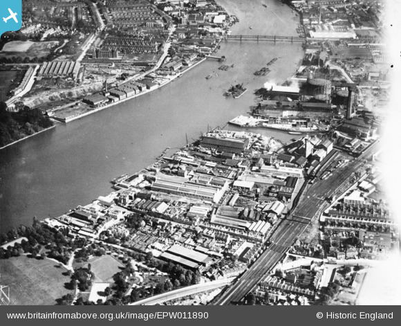
EPW011890 ENGLAND (1924). Thorley's Food Works and environs, Wandsworth, 1924. This image has been produced from a print affected by flare.
© Copyright OpenStreetMap contributors and licensed by the OpenStreetMap Foundation. 2026. Cartography is licensed as CC BY-SA.
Nearby Images (3)
EPW011890

EPW024942

EPW046833

Details
| Title | [EPW011890] Thorley's Food Works and environs, Wandsworth, 1924. This image has been produced from a print affected by flare. |
| Reference | EPW011890 |
| Date | September-1924 |
| Link | |
| Place name | WANDSWORTH |
| Parish | |
| District | |
| Country | ENGLAND |
| Easting / Northing | 525354, 175265 |
| Longitude / Latitude | -0.19533955101796, 51.46197134146 |
| National Grid Reference | TQ254753 |
Pins

Kentishman |
Saturday 13th of February 2021 12:38:21 PM | |
|
london_lighterman |
Thursday 16th of March 2017 11:20:13 AM | |
Further information regarding the above: West Wharf Receiving Station, Metropolitan Asylums Board. Carnwath Road, Fulham, SW6. One of the three places (the other two were at Rotherhithe and Poplar) in London to which smallpox victims would be brought during the epidemic at the turn of the 19th and 20th Centuries, for onward transport by ambulance ships ('Red Cross', 'White Cross', 'Geneva Cross', 'Albert Victor' and 'Maltese Cross') to Dartford. Three hospital ships were moored there from 1882, (Atlas [men's wards], Endymion [administration, kitchen and laundry] and Castalia [women's wards]) being replaced by the Long Reach Hospital on adjacent land in 1902. The hospital ships were taken out of service and scrapped in 1904. Per 'Lost Hospitals of London' ( https://ezitis.myzen.co.uk/westwharf.html ): 'In 1885 following the compulsory purchase by MAB of riverside premises belonging to a Miss Sullivan, work began on the Receiving Station to serve west London. MAB had been keen to acquire this site as it was in a location within easy drive of the Western Hospital at Fulham and the South Western Hospital at Stockwell. Built on 2 acres of open land on the north bank of the river at Fulham, 500 ft west of Wandsworth Bridge, the West Wharf Receiving Station opened in 1885. ... The land side was ... fenced and the pier constructed, together with a porter's lodge, receiving houses and ambulance house. A piermaster and pierman were in charge of the premises. By 1886 it had been completed to operational standard. After the smallpox epidemics of 1892-95 and 1901-2 had subsided the Wharves underwent a period of maintenance and major repairs, e.g. to all the dolphins. Between 1903-11 the pontoon at West Wharf was removed for repair. The 1930 the Metropolitan Asylums Board River Ambulance Service became the London County Council River Ambulance Service. The West Wharf closed in the same year due to it being 'no longer required for purpose'. See images EPW001410, EPW024256 and EPW015774 http://dartfordhospitalhistories.org.uk/long-reach/long-reach-introduction/ and for a photograph of the three original hospital ships - https://iiif.wellcomecollection.org/image/L0006809EB.jpg/full/full/0/default.jpg |
Kentishman |
Saturday 13th of February 2021 12:33:48 PM |
|
london_lighterman |
Thursday 16th of March 2017 11:17:31 AM |