
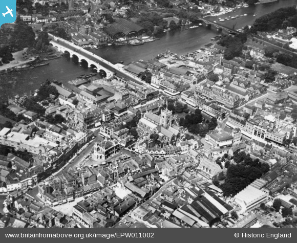
EPW011002 ENGLAND (1924). All Saints' Church, Kingston Bridge and environs, Kingston Upon Thames, 1924. This image has been produced from a print.
© Copyright OpenStreetMap contributors and licensed by the OpenStreetMap Foundation. 2026. Cartography is licensed as CC BY-SA.
Nearby Images (19)
EPW011002

EAW042764

EPR000682

EAW042765

EPW022855

EPW022856

EAW042763

EPW022858

EAW022048

EAW008244

EPW008868

EPR000681

EAW042766

EPR000680

EPW010999

EAW042762

EPW008869

EPW018089

EPW011000

Details
| Title | [EPW011002] All Saints' Church, Kingston Bridge and environs, Kingston Upon Thames, 1924. This image has been produced from a print. |
| Reference | EPW011002 |
| Date | July-1924 |
| Link | |
| Place name | KINGSTON UPON THAMES |
| Parish | |
| District | |
| Country | ENGLAND |
| Easting / Northing | 517884, 169301 |
| Longitude / Latitude | -0.30481520871949, 51.409968432308 |
| National Grid Reference | TQ179693 |
Pins
Be the first to add a comment to this image!
User Comment Contributions
Kingston upon Thames |

Alan McFaden |
Wednesday 12th of November 2014 05:19:38 PM |
Kingston Bridge |
Alan McFaden |
Wednesday 12th of November 2014 05:19:04 PM |