
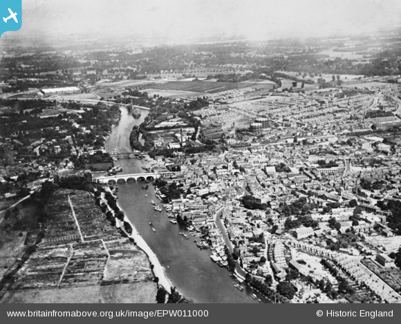
EPW011000 ENGLAND (1924). The town and the River Thames, Kingston upon Thames, from the south, 1924. This image has been produced from a copy-negative.
© Copyright OpenStreetMap contributors and licensed by the OpenStreetMap Foundation. 2026. Cartography is licensed as CC BY-SA.
Nearby Images (11)
EPW011000

EPW018089

EPW010999

EPW008869

EPR000681

EPR000680

EPW008868

EAW042765

EAW042764

EPW005057

EPW011002

Details
| Title | [EPW011000] The town and the River Thames, Kingston upon Thames, from the south, 1924. This image has been produced from a copy-negative. |
| Reference | EPW011000 |
| Date | July-1924 |
| Link | |
| Place name | KINGSTON UPON THAMES |
| Parish | |
| District | |
| Country | ENGLAND |
| Easting / Northing | 517794, 169055 |
| Longitude / Latitude | -0.30619053582248, 51.407775915403 |
| National Grid Reference | TQ178691 |
Pins

KiwiMike |
Wednesday 27th of February 2019 10:13:39 PM | |
|
Leslie B |
Tuesday 8th of March 2016 01:10:17 PM | |
|
gBr |
Monday 12th of January 2015 05:19:33 PM |
User Comment Contributions
Kingston Bridge |

Alan McFaden |
Friday 14th of November 2014 11:51:11 AM |
Kingston upon Thames |
Alan McFaden |
Friday 14th of November 2014 11:50:44 AM |