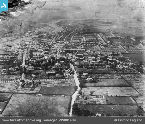
EPW001489 ENGLAND (1920). General view of the town centre, Littlehampton, from the east, 1920
    © Copyright OpenStreetMap contributors and licensed by the OpenStreetMap Foundation. 2025. Cartography is licensed as CC BY-SA.
  
Nearby Images (5)
Details
| Title | [EPW001489] General view of the town centre, Littlehampton, from the east, 1920 | 
| Reference | EPW001489 | 
| Date | July-1920 | 
| Link | |
| Place name | LITTLEHAMPTON | 
| Parish | LITTLEHAMPTON | 
| District | |
| Country | ENGLAND | 
| Easting / Northing | 502921, 102162 | 
| Longitude / Latitude | -0.53906196272172, 50.809293360737 | 
| National Grid Reference | TQ029022 | 
Pins
|  Constable's Anchor Brewery |   alastair wallace | Thursday 29th of October 2015 08:33:15 PM | 
|  St Mary's Church |   Edifis | Monday 6th of October 2014 08:08:42 PM | 
|  Library |   Edifis | Monday 6th of October 2014 08:08:21 PM | 
 
             
  ![[EPW001489] General view of the town centre, Littlehampton, from the east, 1920](http://britainfromabove.org.uk/sites/all/libraries/aerofilms-images/public/100x100/EPW/001/EPW001489.jpg) 
  
                                          ![[EPW039468] The town, Littlehampton, 1932](http://britainfromabove.org.uk/sites/all/libraries/aerofilms-images/public/100x100/EPW/039/EPW039468.jpg) 
 ![[EPW001487] St Mary's Church and the town, Littlehampton, 1920. This image has been produced from a copy-negative.](http://britainfromabove.org.uk/sites/all/libraries/aerofilms-images/public/100x100/EPW/001/EPW001487.jpg) 
 ![[EPW001488] General view of the town centre, Littlehampton, from the south-east, 1920](http://britainfromabove.org.uk/sites/all/libraries/aerofilms-images/public/100x100/EPW/001/EPW001488.jpg) 
 ![[EAW012227] The River Arun, Littlehampton, from the south-east, 1947. This image was marked by Aerofilms Ltd for photo editing.](http://britainfromabove.org.uk/sites/all/libraries/aerofilms-images/public/100x100/EAW/012/EAW012227.jpg)