
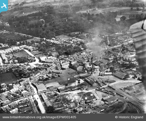
EPW001405 ENGLAND (1920). The Ind Coope and Co Romford Brewery and environs, Romford, 1920. This image has been produced from a print.
© Copyright OpenStreetMap contributors and licensed by the OpenStreetMap Foundation. 2026. Cartography is licensed as CC BY-SA.
Nearby Images (7)
EPW001405

EPW001390

EPW006268

EPW001391

EPW001394

EPW001393

EPW001392

Details
| Title | [EPW001405] The Ind Coope and Co Romford Brewery and environs, Romford, 1920. This image has been produced from a print. |
| Reference | EPW001405 |
| Date | 7-June-1920 |
| Link | |
| Place name | ROMFORD |
| Parish | |
| District | |
| Country | ENGLAND |
| Easting / Northing | 551082, 188841 |
| Longitude / Latitude | 0.18061182853972, 51.577681952286 |
| National Grid Reference | TQ511888 |
Pins

OldManBrook |
Tuesday 19th of September 2023 10:34:37 PM | |
|
jonnyace |
Tuesday 18th of July 2023 10:17:31 PM | |
|
jonnyace |
Tuesday 18th of July 2023 10:16:31 PM | |
|
n1dom |
Saturday 8th of August 2015 06:25:44 AM | |
|
John Wass |
Monday 22nd of June 2015 03:31:27 PM | |
|
GeoffR |
Tuesday 20th of January 2015 05:25:09 PM | |
|
Chelsea61 |
Wednesday 26th of November 2014 06:58:25 PM |
User Comment Contributions
The Ind Coope brewery, Romford. Closed in 1992 and now the location of a shopping mall, creatively called, The Brewery. Somewhere behind the smog sits the Golden Lion PH, which is still open today and features the original arch leading to the coach area and stables. |
GeoffR |
Tuesday 20th of January 2015 05:28:08 PM |