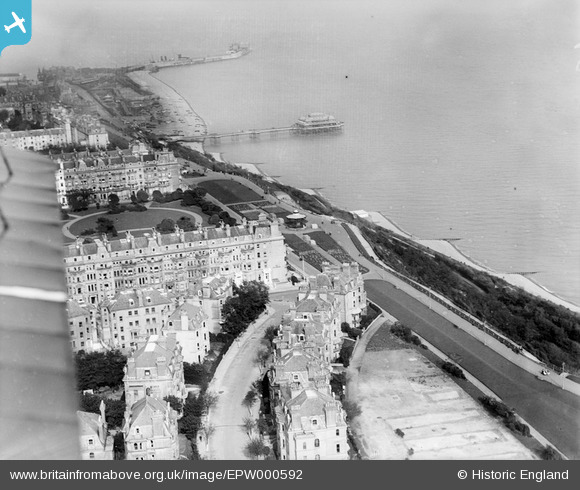
EPW000592 ENGLAND (1920). Clifton Crescent and Westcliff, Folkestone, from the west, 1920
    © Copyright OpenStreetMap contributors and licensed by the OpenStreetMap Foundation. 2025. Cartography is licensed as CC BY-SA.
  
Nearby Images (16)
Details
| Title | [EPW000592] Clifton Crescent and Westcliff, Folkestone, from the west, 1920 | 
| Reference | EPW000592 | 
| Date | May-1920 | 
| Link | |
| Place name | FOLKESTONE | 
| Parish | FOLKESTONE | 
| District | |
| Country | ENGLAND | 
| Easting / Northing | 622028, 135463 | 
| Longitude / Latitude | 1.1699135743189, 51.074936567204 | 
| National Grid Reference | TR220355 | 
Pins
|  Foundations of YMCA cookhouse and canteen - Rest Camp No. 3 |   Paolo | Tuesday 5th of November 2013 05:57:26 PM | 
 
             
  ![[EPW000592] Clifton Crescent and Westcliff, Folkestone, from the west, 1920](http://britainfromabove.org.uk/sites/all/libraries/aerofilms-images/public/100x100/EPW/000/EPW000592.jpg) 
  
                                          ![[EPW000082] Clifton Crescent and Holy Trinity Church, Folkestone, 1920](http://britainfromabove.org.uk/sites/all/libraries/aerofilms-images/public/100x100/EPW/000/EPW000082.jpg) 
 ![[EAW024829] Clifton Crescent and environs, Folkestone, 1949](http://britainfromabove.org.uk/sites/all/libraries/aerofilms-images/public/100x100/EAW/024/EAW024829.jpg) 
 ![[EPW000583] Clifton Crescent, Folkestone, 1920](http://britainfromabove.org.uk/sites/all/libraries/aerofilms-images/public/100x100/EPW/000/EPW000583.jpg) 
 ![[EPW000085] The Leas, Folkestone, 1920](http://britainfromabove.org.uk/sites/all/libraries/aerofilms-images/public/100x100/EPW/000/EPW000085.jpg) 
 ![[EAW002375] The Leas, Folkestone, 1946](http://britainfromabove.org.uk/sites/all/libraries/aerofilms-images/public/100x100/EAW/002/EAW002375.jpg) 
 ![[EAW002374] Clifton Crescent and The Leas, Folkestone, 1946](http://britainfromabove.org.uk/sites/all/libraries/aerofilms-images/public/100x100/EAW/002/EAW002374.jpg) 
 ![[EPW000366] Clifton Crescent, Folkestone, 1920](http://britainfromabove.org.uk/sites/all/libraries/aerofilms-images/public/100x100/EPW/000/EPW000366.jpg) 
 ![[EAW024833] West Cliff, Folkestone, from the south-west, 1949](http://britainfromabove.org.uk/sites/all/libraries/aerofilms-images/public/100x100/EAW/024/EAW024833.jpg) 
 ![[EPW009201] Clifton Gardens and The Leas, Folkestone, 1923](http://britainfromabove.org.uk/sites/all/libraries/aerofilms-images/public/100x100/EPW/009/EPW009201.jpg) 
 ![[EAW002854] West Cliff, Clifton Gardens and the surrounding residential area, Folkestone, 1946](http://britainfromabove.org.uk/sites/all/libraries/aerofilms-images/public/100x100/EAW/002/EAW002854.jpg) 
 ![[EPW000364] Clifton Gardens, Folkestone, 1920](http://britainfromabove.org.uk/sites/all/libraries/aerofilms-images/public/100x100/EPW/000/EPW000364.jpg) 
 ![[EAW024828] The bandstand and the Pulhamite Rock Garden on the Leas, Folkestone, 1949](http://britainfromabove.org.uk/sites/all/libraries/aerofilms-images/public/100x100/EAW/024/EAW024828.jpg) 
 ![[EAW024830] West Cliff, Folkestone, from the south-west, 1949](http://britainfromabove.org.uk/sites/all/libraries/aerofilms-images/public/100x100/EAW/024/EAW024830.jpg) 
 ![[EPW000077] Cliff Railway, Folkestone, 1920](http://britainfromabove.org.uk/sites/all/libraries/aerofilms-images/public/100x100/EPW/000/EPW000077.jpg) 
 ![[EPW000588] Augusta Gardens, Folkestone, from the north-west, 1920](http://britainfromabove.org.uk/sites/all/libraries/aerofilms-images/public/100x100/EPW/000/EPW000588.jpg)