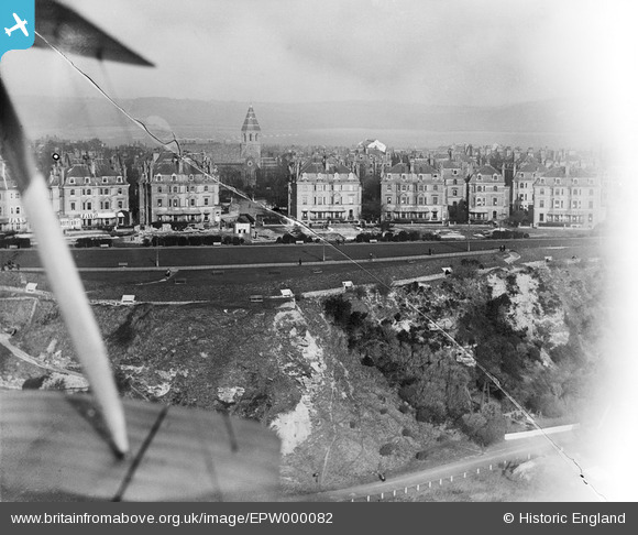
EPW000082 ENGLAND (1920). Clifton Crescent and Holy Trinity Church, Folkestone, 1920
    © Copyright OpenStreetMap contributors and licensed by the OpenStreetMap Foundation. 2025. Cartography is licensed as CC BY-SA.
  
Nearby Images (14)
Details
| Title | [EPW000082] Clifton Crescent and Holy Trinity Church, Folkestone, 1920 | 
| Reference | EPW000082 | 
| Date | March-1920 | 
| Link | |
| Place name | FOLKESTONE | 
| Parish | FOLKESTONE | 
| District | |
| Country | ENGLAND | 
| Easting / Northing | 622000, 135426 | 
| Longitude / Latitude | 1.169491751057, 51.074615161761 | 
| National Grid Reference | TR220354 | 
Pins
|  Demolition of YMCA cookhouse for Rest Camp No. 3 under way. |   Paolo | Wednesday 5th of November 2014 05:42:09 PM | 
User Comment Contributions
| Notice how many of the properties have posters in the ground and second floor windows.  These are For Sale notices.  Before 1914 the vast majority of these properties were private residences.  Purchasers converted them into Hotels. |   Paolo | Wednesday 5th of November 2014 05:47:17 PM | 
 
             
  ![[EPW000082] Clifton Crescent and Holy Trinity Church, Folkestone, 1920](http://britainfromabove.org.uk/sites/all/libraries/aerofilms-images/public/100x100/EPW/000/EPW000082.jpg) 
  
                                          ![[EPW000592] Clifton Crescent and Westcliff, Folkestone, from the west, 1920](http://britainfromabove.org.uk/sites/all/libraries/aerofilms-images/public/100x100/EPW/000/EPW000592.jpg) 
 ![[EPW000583] Clifton Crescent, Folkestone, 1920](http://britainfromabove.org.uk/sites/all/libraries/aerofilms-images/public/100x100/EPW/000/EPW000583.jpg) 
 ![[EPW000085] The Leas, Folkestone, 1920](http://britainfromabove.org.uk/sites/all/libraries/aerofilms-images/public/100x100/EPW/000/EPW000085.jpg) 
 ![[EAW024829] Clifton Crescent and environs, Folkestone, 1949](http://britainfromabove.org.uk/sites/all/libraries/aerofilms-images/public/100x100/EAW/024/EAW024829.jpg) 
 ![[EAW024833] West Cliff, Folkestone, from the south-west, 1949](http://britainfromabove.org.uk/sites/all/libraries/aerofilms-images/public/100x100/EAW/024/EAW024833.jpg) 
 ![[EAW002374] Clifton Crescent and The Leas, Folkestone, 1946](http://britainfromabove.org.uk/sites/all/libraries/aerofilms-images/public/100x100/EAW/002/EAW002374.jpg) 
 ![[EAW002375] The Leas, Folkestone, 1946](http://britainfromabove.org.uk/sites/all/libraries/aerofilms-images/public/100x100/EAW/002/EAW002375.jpg) 
 ![[EPW009201] Clifton Gardens and The Leas, Folkestone, 1923](http://britainfromabove.org.uk/sites/all/libraries/aerofilms-images/public/100x100/EPW/009/EPW009201.jpg) 
 ![[EPW000366] Clifton Crescent, Folkestone, 1920](http://britainfromabove.org.uk/sites/all/libraries/aerofilms-images/public/100x100/EPW/000/EPW000366.jpg) 
 ![[EAW002854] West Cliff, Clifton Gardens and the surrounding residential area, Folkestone, 1946](http://britainfromabove.org.uk/sites/all/libraries/aerofilms-images/public/100x100/EAW/002/EAW002854.jpg) 
 ![[EPW000364] Clifton Gardens, Folkestone, 1920](http://britainfromabove.org.uk/sites/all/libraries/aerofilms-images/public/100x100/EPW/000/EPW000364.jpg) 
 ![[EPW000077] Cliff Railway, Folkestone, 1920](http://britainfromabove.org.uk/sites/all/libraries/aerofilms-images/public/100x100/EPW/000/EPW000077.jpg) 
 ![[EAW024828] The bandstand and the Pulhamite Rock Garden on the Leas, Folkestone, 1949](http://britainfromabove.org.uk/sites/all/libraries/aerofilms-images/public/100x100/EAW/024/EAW024828.jpg)