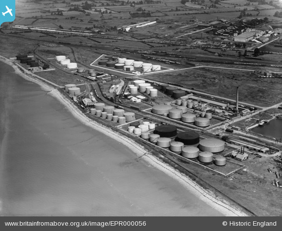
EPR000056 ENGLAND (1934). The fuel storage depot opposite the Avonmouth Works, Avonmouth, 1934
    © Copyright OpenStreetMap contributors and licensed by the OpenStreetMap Foundation. 2025. Cartography is licensed as CC BY-SA.
  
Details
| Title | [EPR000056] The fuel storage depot opposite the Avonmouth Works, Avonmouth, 1934 | 
| Reference | EPR000056 | 
| Date | 4-July-1934 | 
| Link | |
| Place name | AVONMOUTH | 
| Parish | |
| District | |
| Country | ENGLAND | 
| Easting / Northing | 351255, 179600 | 
| Longitude / Latitude | -2.70251583257, 51.512738491884 | 
| National Grid Reference | ST513796 | 
Pins
Be the first to add a comment to this image!
 
             
  ![[EPR000056] The fuel storage depot opposite the Avonmouth Works, Avonmouth, 1934](http://britainfromabove.org.uk/sites/all/libraries/aerofilms-images/public/100x100/EPR/000/EPR000056.jpg) 
  
                                          ![[EPW005482] The Timber Pond and fuel storage depot, Avonmouth, 1921](http://britainfromabove.org.uk/sites/all/libraries/aerofilms-images/public/100x100/EPW/005/EPW005482.jpg) 
 ![[EAW002244] The Port of Bristol Authority Royal Edward Docks, Avonmouth, 1946. This image has been produced from a print.](http://britainfromabove.org.uk/sites/all/libraries/aerofilms-images/public/100x100/EAW/002/EAW002244.jpg) 
 ![[EAW002252] The Port of Bristol Authority Royal Edward Docks, Avonmouth, 1946. This image has been produced from a print.](http://britainfromabove.org.uk/sites/all/libraries/aerofilms-images/public/100x100/EAW/002/EAW002252.jpg)