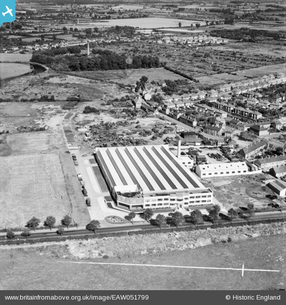
EAW051799 ENGLAND (1953). The Murphy Brothers Ltd Factory on Loughborough Road and environs, Rushey Mead, 1953. This image was marked by Aerofilms Ltd for photo editing.
© Copyright OpenStreetMap contributors and licensed by the OpenStreetMap Foundation. 2025. Cartography is licensed as CC BY-SA.
Nearby Images (9)
Details
| Title | [EAW051799] The Murphy Brothers Ltd Factory on Loughborough Road and environs, Rushey Mead, 1953. This image was marked by Aerofilms Ltd for photo editing. |
| Reference | EAW051799 |
| Date | 1-September-1953 |
| Link | |
| Place name | RUSHEY MEAD |
| Parish | |
| District | |
| Country | ENGLAND |
| Easting / Northing | 459350, 307527 |
| Longitude / Latitude | -1.1223827729823, 52.661861580407 |
| National Grid Reference | SK594075 |
Pins

John Wass |
Thursday 14th of May 2015 03:27:11 PM |


![[EAW051799] The Murphy Brothers Ltd Factory on Loughborough Road and environs, Rushey Mead, 1953. This image was marked by Aerofilms Ltd for photo editing.](http://britainfromabove.org.uk/sites/all/libraries/aerofilms-images/public/100x100/EAW/051/EAW051799.jpg)
![[EAW051798] The Murphy Brothers Ltd Factory on Loughborough Road and environs, Rushey Mead, 1953. This image was marked by Aerofilms Ltd for photo editing.](http://britainfromabove.org.uk/sites/all/libraries/aerofilms-images/public/100x100/EAW/051/EAW051798.jpg)
![[EAW051800] The Murphy Brothers Ltd Factory on Loughborough Road and environs, Rushey Mead, 1953. This image was marked by Aerofilms Ltd for photo editing.](http://britainfromabove.org.uk/sites/all/libraries/aerofilms-images/public/100x100/EAW/051/EAW051800.jpg)
![[EAW051796] The Murphy Brothers Ltd Factory on Loughborough Road and environs, Rushey Mead, 1953. This image was marked by Aerofilms Ltd for photo editing.](http://britainfromabove.org.uk/sites/all/libraries/aerofilms-images/public/100x100/EAW/051/EAW051796.jpg)
![[EAW051794] The Murphy Brothers Ltd Factory on Loughborough Road, New Bridge and environs, Rushey Mead, 1953. This image was marked by Aerofilms Ltd for photo editing.](http://britainfromabove.org.uk/sites/all/libraries/aerofilms-images/public/100x100/EAW/051/EAW051794.jpg)
![[EAW051795] The Murphy Brothers Ltd Factory on Loughborough Road and environs, Rushey Mead, 1953. This image was marked by Aerofilms Ltd for photo editing.](http://britainfromabove.org.uk/sites/all/libraries/aerofilms-images/public/100x100/EAW/051/EAW051795.jpg)
![[EAW051793] The Murphy Brothers Ltd Factory on Loughborough Road, the River Soar and environs, Rushey Mead, 1953. This image was marked by Aerofilms Ltd for photo editing.](http://britainfromabove.org.uk/sites/all/libraries/aerofilms-images/public/100x100/EAW/051/EAW051793.jpg)
![[EAW051801] The Murphy Brothers Ltd Factory on Loughborough Road, the River Soar and environs, Rushey Mead, 1953. This image was marked by Aerofilms Ltd for photo editing.](http://britainfromabove.org.uk/sites/all/libraries/aerofilms-images/public/100x100/EAW/051/EAW051801.jpg)
![[EAW051797] The Murphy Brothers Ltd Factory on Loughborough Road, the River Soar and environs, Rushey Mead, 1953. This image was marked by Aerofilms Ltd for photo editing.](http://britainfromabove.org.uk/sites/all/libraries/aerofilms-images/public/100x100/EAW/051/EAW051797.jpg)