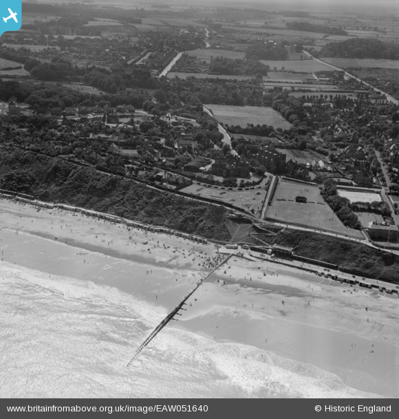
EAW051640 ENGLAND (1953). The beach, Doctor's Steps and environs, Cromer, 1953
    © Copyright OpenStreetMap contributors and licensed by the OpenStreetMap Foundation. 2025. Cartography is licensed as CC BY-SA.
  
Nearby Images (5)
Details
| Title | [EAW051640] The beach, Doctor's Steps and environs, Cromer, 1953 | 
| Reference | EAW051640 | 
| Date | 26-August-1953 | 
| Link | |
| Place name | CROMER | 
| Parish | CROMER | 
| District | |
| Country | ENGLAND | 
| Easting / Northing | 622337, 342084 | 
| Longitude / Latitude | 1.3084572738991, 52.92972565773 | 
| National Grid Reference | TG223421 | 
Pins
|  WW2 Structure TBC |   Sparky | Saturday 28th of October 2017 11:32:54 PM | 
 
             
  ![[EAW051640] The beach, Doctor's Steps and environs, Cromer, 1953](http://britainfromabove.org.uk/sites/all/libraries/aerofilms-images/public/100x100/EAW/051/EAW051640.jpg) 
  
                                          ![[EAW051639] The beach, Doctor's Steps and environs, Cromer, 1953](http://britainfromabove.org.uk/sites/all/libraries/aerofilms-images/public/100x100/EAW/051/EAW051639.jpg) 
 ![[EPW039247] The pier and town, Cromer, from the east, 1932](http://britainfromabove.org.uk/sites/all/libraries/aerofilms-images/public/100x100/EPW/039/EPW039247.jpg) 
 ![[EAW051641] The town and seafront, Cromer, 1953](http://britainfromabove.org.uk/sites/all/libraries/aerofilms-images/public/100x100/EAW/051/EAW051641.jpg) 
 ![[EPW001816] View of Cromer, the pier and St Peter and St Paul's Church, Cromer, 1920](http://britainfromabove.org.uk/sites/all/libraries/aerofilms-images/public/100x100/EPW/001/EPW001816.jpg)