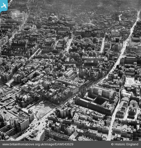
EAW043629 ENGLAND (1952). Holborn, High Holborn, Lincoln's Inn Fields and the surrounding city, London, 1952
    © Copyright OpenStreetMap contributors and licensed by the OpenStreetMap Foundation. 2025. Cartography is licensed as CC BY-SA.
  
Nearby Images (24)
Details
| Title | [EAW043629] Holborn, High Holborn, Lincoln's Inn Fields and the surrounding city, London, 1952 | 
| Reference | EAW043629 | 
| Date | 4-July-1952 | 
| Link | |
| Place name | LONDON | 
| Parish | |
| District | |
| Country | ENGLAND | 
| Easting / Northing | 531128, 181487 | 
| Longitude / Latitude | -0.10994995869978, 51.516583959573 | 
| National Grid Reference | TQ311815 | 
Pins
|  The Globe public house, corner of Greville Street and Hatton Garden |   Robin | Wednesday 15th of April 2020 03:12:32 PM | 
|  7 Holborn Circus.
This empty piece of ground is explained in Image EPW005904 which was taken in March 1921
(See attached pic). |   Billy Turner | Friday 24th of March 2017 09:38:00 PM | 
|  Gamages Department Store (from the rear), Holborn, EC1 |   billyfern | Friday 3rd of October 2014 05:24:38 PM | 
|   Alan McFaden | Saturday 14th of June 2014 10:06:38 AM | |
|   Alan McFaden | Saturday 14th of June 2014 10:04:32 AM | |
|   Alan McFaden | Saturday 14th of June 2014 10:02:44 AM | |
|   Alan McFaden | Saturday 14th of June 2014 10:02:05 AM | |
|   Alan McFaden | Saturday 14th of June 2014 10:01:17 AM | |
|   Alan McFaden | Saturday 14th of June 2014 10:00:02 AM | |
|   Alan McFaden | Saturday 14th of June 2014 09:58:17 AM | |
|   Alan McFaden | Saturday 14th of June 2014 09:56:31 AM | |
|   Alan McFaden | Saturday 14th of June 2014 09:55:39 AM | |
|   Alan McFaden | Saturday 14th of June 2014 09:54:50 AM | |
|   Alan McFaden | Saturday 14th of June 2014 09:53:21 AM | |
|  New Oxford Street, WC2 |   billyfern | Friday 13th of June 2014 06:05:51 PM | 
|  Holborn Viaduct, EC1 |   billyfern | Friday 13th of June 2014 06:03:40 PM | 
|  Strand, WC2 |   billyfern | Friday 13th of June 2014 06:02:49 PM | 
|  Aldwych, WC2 |   billyfern | Friday 13th of June 2014 06:01:48 PM | 
|  High Holborn, WC1 |   billyfern | Friday 13th of June 2014 05:59:30 PM | 
|  Lincolns Inn Fields, WC2 |   billyfern | Friday 13th of June 2014 05:58:25 PM | 
|  Holborn Circus, EC1 |   billyfern | Friday 13th of June 2014 05:56:21 PM | 
 
             
  ![[EAW043629] Holborn, High Holborn, Lincoln's Inn Fields and the surrounding city, London, 1952](http://britainfromabove.org.uk/sites/all/libraries/aerofilms-images/public/100x100/EAW/043/EAW043629.jpg) 
  
                                          ![[EAW010068] High Holborn, Holborn Bar, Gray's Inn and environs, Holborn, 1947](http://britainfromabove.org.uk/sites/all/libraries/aerofilms-images/public/100x100/EAW/010/EAW010068.jpg) 
 ![[EPW005923] The Prudential Assurance Building, Holborn, 1921](http://britainfromabove.org.uk/sites/all/libraries/aerofilms-images/public/100x100/EPW/005/EPW005923.jpg) 
 ![[EAW018707] Lincoln's Inn, Holborn, 1948. This image has been produced from a print.](http://britainfromabove.org.uk/sites/all/libraries/aerofilms-images/public/100x100/EAW/018/EAW018707.jpg) 
 ![[EAW010047] Holborn Bars and environs, Holborn, 1947](http://britainfromabove.org.uk/sites/all/libraries/aerofilms-images/public/100x100/EAW/010/EAW010047.jpg) 
 ![[EAW018706] Lincoln's Inn and environs, Holborn, 1948. This image has been produced from a print.](http://britainfromabove.org.uk/sites/all/libraries/aerofilms-images/public/100x100/EAW/018/EAW018706.jpg) 
 ![[EAW043626] High Holborn, Holborn and the surrounding city, London, from the east, 1952](http://britainfromabove.org.uk/sites/all/libraries/aerofilms-images/public/100x100/EAW/043/EAW043626.jpg) 
 ![[EAW010043] Holborn Bars and environs, Holborn, 1947. This image was marked by Aerofilms Ltd for photo editing.](http://britainfromabove.org.uk/sites/all/libraries/aerofilms-images/public/100x100/EAW/010/EAW010043.jpg) 
 ![[EAW010042] Holborn Bars and environs, Holborn, 1947. This image was marked by Aerofilms Ltd for photo editing.](http://britainfromabove.org.uk/sites/all/libraries/aerofilms-images/public/100x100/EAW/010/EAW010042.jpg) 
 ![[EPW005133] Gray's Inn and environs, London, 1920](http://britainfromabove.org.uk/sites/all/libraries/aerofilms-images/public/100x100/EPW/005/EPW005133.jpg) 
 ![[EAW010046] Holborn Bars and environs, Holborn, 1947. This image was marked by Aerofilms Ltd for photo editing.](http://britainfromabove.org.uk/sites/all/libraries/aerofilms-images/public/100x100/EAW/010/EAW010046.jpg) 
 ![[EAW010044] Holborn Bars and environs, Holborn, 1947. This image was marked by Aerofilms Ltd for photo editing.](http://britainfromabove.org.uk/sites/all/libraries/aerofilms-images/public/100x100/EAW/010/EAW010044.jpg) 
 ![[EAW010045] Holborn Bars and environs, Holborn, 1947. This image was marked by Aerofilms Ltd for photo editing.](http://britainfromabove.org.uk/sites/all/libraries/aerofilms-images/public/100x100/EAW/010/EAW010045.jpg) 
 ![[EAW011183] The Royal Courts of Justice, Public Record Office (now King's College London) and environs, Strand, 1947](http://britainfromabove.org.uk/sites/all/libraries/aerofilms-images/public/100x100/EAW/011/EAW011183.jpg) 
 ![[EAW018344] High Holborn and environs, Holborn, 1948. This image has been produced from a print.](http://britainfromabove.org.uk/sites/all/libraries/aerofilms-images/public/100x100/EAW/018/EAW018344.jpg) 
 ![[EAW010041] Holborn Bars, Leather Lane, Gray's Inn Road and environs, Holborn, 1947. This image was marked by Aerofilms Ltd for photo editing.](http://britainfromabove.org.uk/sites/all/libraries/aerofilms-images/public/100x100/EAW/010/EAW010041.jpg) 
 ![[EAW020406] Unilever House, Farringdon Street, Farringdon Road and environs, Holborn, 1948](http://britainfromabove.org.uk/sites/all/libraries/aerofilms-images/public/100x100/EAW/020/EAW020406.jpg) 
 ![[EPW005998] The Prudential Assurance Company and surrounding area, Holborn, 1921. This image has been produced from a print affected by flare.](http://britainfromabove.org.uk/sites/all/libraries/aerofilms-images/public/100x100/EPW/005/EPW005998.jpg) 
 ![[EAW043627] Holborn, Lincoln's Inn Fields and the surrounding city, Holborn, from the north-east, 1952](http://britainfromabove.org.uk/sites/all/libraries/aerofilms-images/public/100x100/EAW/043/EAW043627.jpg) 
 ![[EAW011187] The Prudential Assurance Building and environs, Holborn, 1947](http://britainfromabove.org.uk/sites/all/libraries/aerofilms-images/public/100x100/EAW/011/EAW011187.jpg) 
 ![[EAW022422] The area to the north of Fleet Street, London, 1949](http://britainfromabove.org.uk/sites/all/libraries/aerofilms-images/public/100x100/EAW/022/EAW022422.jpg) 
 ![[EAW010073] The area between Fetter Lane, Fleet Street and Shoe Lane, London, 1947](http://britainfromabove.org.uk/sites/all/libraries/aerofilms-images/public/100x100/EAW/010/EAW010073.jpg) 
 ![[EAW011186] Gray's Inn and environs, Holborn, 1947](http://britainfromabove.org.uk/sites/all/libraries/aerofilms-images/public/100x100/EAW/011/EAW011186.jpg) 
 ![[EAW011182] Cleared area around Great New Street following bomb damage and environs, London, 1947](http://britainfromabove.org.uk/sites/all/libraries/aerofilms-images/public/100x100/EAW/011/EAW011182.jpg) 


