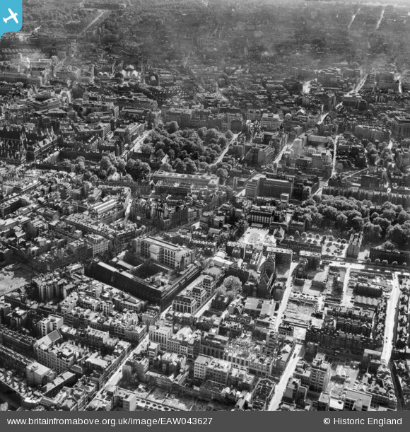
EAW043627 ENGLAND (1952). Holborn, Lincoln's Inn Fields and the surrounding city, Holborn, from the north-east, 1952
    © Copyright OpenStreetMap contributors and licensed by the OpenStreetMap Foundation. 2025. Cartography is licensed as CC BY-SA.
  
Nearby Images (25)
Details
| Title | [EAW043627] Holborn, Lincoln's Inn Fields and the surrounding city, Holborn, from the north-east, 1952 | 
| Reference | EAW043627 | 
| Date | 4-July-1952 | 
| Link | |
| Place name | HOLBORN | 
| Parish | |
| District | |
| Country | ENGLAND | 
| Easting / Northing | 531214, 181730 | 
| Longitude / Latitude | -0.10862061123445, 51.518747967865 | 
| National Grid Reference | TQ312817 | 
Pins
|  Red Lion Square, WC1 |   billyfern | Saturday 4th of October 2014 05:21:24 PM | 
|  Clare Market, WC2 |   billyfern | Saturday 4th of October 2014 05:20:52 PM | 
|  Kingsway, WC2 |   billyfern | Saturday 4th of October 2014 05:20:24 PM | 
|  Aldwych, WC2 |   billyfern | Saturday 4th of October 2014 05:19:40 PM | 
|  Gamages Department Store, EC1  (viewed from rear) |   billyfern | Friday 3rd of October 2014 05:40:16 PM | 
|  Portpool Lane, EC1 |   billyfern | Friday 3rd of October 2014 05:38:00 PM | 
| Class31 | Tuesday 8th of July 2014 10:05:11 PM | |
| Class31 | Tuesday 17th of June 2014 04:58:57 PM | |
| Class31 | Tuesday 17th of June 2014 04:58:15 PM | |
| Class31 | Tuesday 17th of June 2014 04:56:47 PM | |
| Class31 | Tuesday 17th of June 2014 04:55:03 PM | |
| Class31 | Tuesday 17th of June 2014 04:54:16 PM | |
| Class31 | Tuesday 17th of June 2014 04:51:31 PM | |
|  High Holborn, WC1 |   billyfern | Friday 13th of June 2014 06:14:04 PM | 
|  Grays Inn Road, WC1 |   billyfern | Friday 13th of June 2014 06:13:11 PM | 
|  Lincolns Inn Fields, WC2 |   billyfern | Friday 13th of June 2014 06:12:24 PM | 
 
             
  ![[EAW043627] Holborn, Lincoln's Inn Fields and the surrounding city, Holborn, from the north-east, 1952](http://britainfromabove.org.uk/sites/all/libraries/aerofilms-images/public/100x100/EAW/043/EAW043627.jpg) 
  
                                          ![[EAW010041] Holborn Bars, Leather Lane, Gray's Inn Road and environs, Holborn, 1947. This image was marked by Aerofilms Ltd for photo editing.](http://britainfromabove.org.uk/sites/all/libraries/aerofilms-images/public/100x100/EAW/010/EAW010041.jpg) 
 ![[EAW010046] Holborn Bars and environs, Holborn, 1947. This image was marked by Aerofilms Ltd for photo editing.](http://britainfromabove.org.uk/sites/all/libraries/aerofilms-images/public/100x100/EAW/010/EAW010046.jpg) 
 ![[EAW010045] Holborn Bars and environs, Holborn, 1947. This image was marked by Aerofilms Ltd for photo editing.](http://britainfromabove.org.uk/sites/all/libraries/aerofilms-images/public/100x100/EAW/010/EAW010045.jpg) 
 ![[EAW010042] Holborn Bars and environs, Holborn, 1947. This image was marked by Aerofilms Ltd for photo editing.](http://britainfromabove.org.uk/sites/all/libraries/aerofilms-images/public/100x100/EAW/010/EAW010042.jpg) 
 ![[EAW010044] Holborn Bars and environs, Holborn, 1947. This image was marked by Aerofilms Ltd for photo editing.](http://britainfromabove.org.uk/sites/all/libraries/aerofilms-images/public/100x100/EAW/010/EAW010044.jpg) 
 ![[EAW011187] The Prudential Assurance Building and environs, Holborn, 1947](http://britainfromabove.org.uk/sites/all/libraries/aerofilms-images/public/100x100/EAW/011/EAW011187.jpg) 
 ![[EPW005998] The Prudential Assurance Company and surrounding area, Holborn, 1921. This image has been produced from a print affected by flare.](http://britainfromabove.org.uk/sites/all/libraries/aerofilms-images/public/100x100/EPW/005/EPW005998.jpg) 
 ![[EAW010040] Holborn Bars, Leather Lane and environs, Holborn, 1947. This image was marked by Aerofilms Ltd for photo editing.](http://britainfromabove.org.uk/sites/all/libraries/aerofilms-images/public/100x100/EAW/010/EAW010040.jpg) 
 ![[EAW010043] Holborn Bars and environs, Holborn, 1947. This image was marked by Aerofilms Ltd for photo editing.](http://britainfromabove.org.uk/sites/all/libraries/aerofilms-images/public/100x100/EAW/010/EAW010043.jpg) 
 ![[EAW010048] Holborn Bars, Gray's Inn and environs, Holborn, 1947. This image was marked by Aerofilms Ltd for photo editing.](http://britainfromabove.org.uk/sites/all/libraries/aerofilms-images/public/100x100/EAW/010/EAW010048.jpg) 
 ![[EAW010039] Holborn Bars, Leather Lane and environs, Holborn, 1947](http://britainfromabove.org.uk/sites/all/libraries/aerofilms-images/public/100x100/EAW/010/EAW010039.jpg) 
 ![[EPW005923] The Prudential Assurance Building, Holborn, 1921](http://britainfromabove.org.uk/sites/all/libraries/aerofilms-images/public/100x100/EPW/005/EPW005923.jpg) 
 ![[EAW010047] Holborn Bars and environs, Holborn, 1947](http://britainfromabove.org.uk/sites/all/libraries/aerofilms-images/public/100x100/EAW/010/EAW010047.jpg) 
 ![[EAW010068] High Holborn, Holborn Bar, Gray's Inn and environs, Holborn, 1947](http://britainfromabove.org.uk/sites/all/libraries/aerofilms-images/public/100x100/EAW/010/EAW010068.jpg) 
 ![[EAW020406] Unilever House, Farringdon Street, Farringdon Road and environs, Holborn, 1948](http://britainfromabove.org.uk/sites/all/libraries/aerofilms-images/public/100x100/EAW/020/EAW020406.jpg) 
 ![[EPW005133] Gray's Inn and environs, London, 1920](http://britainfromabove.org.uk/sites/all/libraries/aerofilms-images/public/100x100/EPW/005/EPW005133.jpg) 
 ![[EAW018344] High Holborn and environs, Holborn, 1948. This image has been produced from a print.](http://britainfromabove.org.uk/sites/all/libraries/aerofilms-images/public/100x100/EAW/018/EAW018344.jpg) 
 ![[EPW005904] Holborn Circus, London, 1921. This image has been produced from a copy-negative.](http://britainfromabove.org.uk/sites/all/libraries/aerofilms-images/public/100x100/EPW/005/EPW005904.jpg) 
 ![[EAW043629] Holborn, High Holborn, Lincoln's Inn Fields and the surrounding city, London, 1952](http://britainfromabove.org.uk/sites/all/libraries/aerofilms-images/public/100x100/EAW/043/EAW043629.jpg) 
 ![[EAW043626] High Holborn, Holborn and the surrounding city, London, from the east, 1952](http://britainfromabove.org.uk/sites/all/libraries/aerofilms-images/public/100x100/EAW/043/EAW043626.jpg) 
 ![[EAW011205] Hatton Gardens and environs, Holborn, 1947](http://britainfromabove.org.uk/sites/all/libraries/aerofilms-images/public/100x100/EAW/011/EAW011205.jpg) 
 ![[EAW011206] The Bourne Estate and environs, Holborn, 1947](http://britainfromabove.org.uk/sites/all/libraries/aerofilms-images/public/100x100/EAW/011/EAW011206.jpg) 
 ![[EPW021402] St Paul's Cathedral and the River Thames, London, from the north-west, 1928](http://britainfromabove.org.uk/sites/all/libraries/aerofilms-images/public/100x100/EPW/021/EPW021402.jpg) 
 ![[EAW010076] Farringdon Road, Farringdon Station and environs, Holborn, 1947](http://britainfromabove.org.uk/sites/all/libraries/aerofilms-images/public/100x100/EAW/010/EAW010076.jpg)