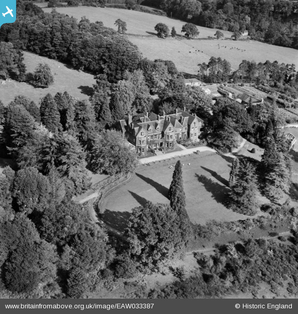
EAW033387 ENGLAND (1950). Enton Hall Health Hydro, Witley, 1950
© Copyright OpenStreetMap contributors and licensed by the OpenStreetMap Foundation. 2025. Cartography is licensed as CC BY-SA.
Nearby Images (33)
Details
| Title | [EAW033387] Enton Hall Health Hydro, Witley, 1950 |
| Reference | EAW033387 |
| Date | 10-October-1950 |
| Link | |
| Place name | WITLEY |
| Parish | WITLEY |
| District | |
| Country | ENGLAND |
| Easting / Northing | 495582, 139275 |
| Longitude / Latitude | -0.63344411365334, 51.14422556774 |
| National Grid Reference | SU956393 |
Pins
Be the first to add a comment to this image!


![[EAW033387] Enton Hall Health Hydro, Witley, 1950](http://britainfromabove.org.uk/sites/all/libraries/aerofilms-images/public/100x100/EAW/033/EAW033387.jpg)
![[EAW036638] Enton Hall Health Hydro, Witley, 1951. This image has been produced from a print marked by Aerofilms Ltd for photo editing.](http://britainfromabove.org.uk/sites/all/libraries/aerofilms-images/public/100x100/EAW/036/EAW036638.jpg)
![[EAW033396] Enton Hall Health Hydro, Witley, 1950. This image was marked by Aerofilms Ltd for photo editing.](http://britainfromabove.org.uk/sites/all/libraries/aerofilms-images/public/100x100/EAW/033/EAW033396.jpg)
![[EAW036631] Enton Hall Health Hydro, Witley, 1951. This image has been produced from a print marked by Aerofilms Ltd for photo editing.](http://britainfromabove.org.uk/sites/all/libraries/aerofilms-images/public/100x100/EAW/036/EAW036631.jpg)
![[EAW033389] Enton Hall Health Hydro, Witley, 1950](http://britainfromabove.org.uk/sites/all/libraries/aerofilms-images/public/100x100/EAW/033/EAW033389.jpg)
![[EAW031610] Enton Hall Health Hydro, Witley, 1950. This image was marked by Aerofilms Ltd for photo editing.](http://britainfromabove.org.uk/sites/all/libraries/aerofilms-images/public/100x100/EAW/031/EAW031610.jpg)
![[EAW036632] Enton Hall Health Hydro, Witley, 1951. This image has been produced from a print marked by Aerofilms Ltd for photo editing.](http://britainfromabove.org.uk/sites/all/libraries/aerofilms-images/public/100x100/EAW/036/EAW036632.jpg)
![[EAW031609] Enton Hall Health Hydro, Witley, 1950. This image was marked by Aerofilms Ltd for photo editing.](http://britainfromabove.org.uk/sites/all/libraries/aerofilms-images/public/100x100/EAW/031/EAW031609.jpg)
![[EAW033388] Enton Hall Health Hydro, Witley, 1950](http://britainfromabove.org.uk/sites/all/libraries/aerofilms-images/public/100x100/EAW/033/EAW033388.jpg)
![[EAW036637] Enton Hall Health Hydro, Witley, 1951. This image has been produced from a print marked by Aerofilms Ltd for photo editing.](http://britainfromabove.org.uk/sites/all/libraries/aerofilms-images/public/100x100/EAW/036/EAW036637.jpg)
![[EAW031611] Enton Hall Health Hydro, Witley, 1950. This image was marked by Aerofilms Ltd for photo editing.](http://britainfromabove.org.uk/sites/all/libraries/aerofilms-images/public/100x100/EAW/031/EAW031611.jpg)
![[EAW031612] Enton Hall Health Hydro, Witley, 1950. This image was marked by Aerofilms Ltd for photo editing.](http://britainfromabove.org.uk/sites/all/libraries/aerofilms-images/public/100x100/EAW/031/EAW031612.jpg)
![[EAW031613] Enton Hall Health Hydro, Witley, 1950. This image was marked by Aerofilms Ltd for photo editing.](http://britainfromabove.org.uk/sites/all/libraries/aerofilms-images/public/100x100/EAW/031/EAW031613.jpg)
![[EAW036636] Enton Hall Health Hydro, Witley, 1951. This image has been produced from a print marked by Aerofilms Ltd for photo editing.](http://britainfromabove.org.uk/sites/all/libraries/aerofilms-images/public/100x100/EAW/036/EAW036636.jpg)
![[EAW033393] Enton Hall Health Hydro, Witley, 1950. This image was marked by Aerofilms Ltd for photo editing.](http://britainfromabove.org.uk/sites/all/libraries/aerofilms-images/public/100x100/EAW/033/EAW033393.jpg)
![[EAW036639] Enton Hall Health Hydro, Witley, 1951. This image has been produced from a print marked by Aerofilms Ltd for photo editing.](http://britainfromabove.org.uk/sites/all/libraries/aerofilms-images/public/100x100/EAW/036/EAW036639.jpg)
![[EAW036633] Enton Hall Health Hydro, Witley, 1951. This image has been produced from a print marked by Aerofilms Ltd for photo editing.](http://britainfromabove.org.uk/sites/all/libraries/aerofilms-images/public/100x100/EAW/036/EAW036633.jpg)
![[EAW036630] Enton Hall Health Hydro, Witley, 1951. This image has been produced from a print.](http://britainfromabove.org.uk/sites/all/libraries/aerofilms-images/public/100x100/EAW/036/EAW036630.jpg)
![[EAW036634] Enton Hall Health Hydro, Witley, 1951. This image has been produced from a print marked by Aerofilms Ltd for photo editing.](http://britainfromabove.org.uk/sites/all/libraries/aerofilms-images/public/100x100/EAW/036/EAW036634.jpg)
![[EAW036635] Enton Hall Health Hydro, Witley, 1951. This image has been produced from a print marked by Aerofilms Ltd for photo editing.](http://britainfromabove.org.uk/sites/all/libraries/aerofilms-images/public/100x100/EAW/036/EAW036635.jpg)
![[EAW033395] Enton Hall Health Hydro and surrounding countryside, Witley, 1950. This image was marked by Aerofilms Ltd for photo editing.](http://britainfromabove.org.uk/sites/all/libraries/aerofilms-images/public/100x100/EAW/033/EAW033395.jpg)
![[EAW036629] Enton Hall Health Hydro, Witley, 1951. This image has been produced from a print marked by Aerofilms Ltd for photo editing.](http://britainfromabove.org.uk/sites/all/libraries/aerofilms-images/public/100x100/EAW/036/EAW036629.jpg)
![[EAW031615] Enton Hall Health Hydro and environs, Witley, 1950. This image was marked by Aerofilms Ltd for photo editing.](http://britainfromabove.org.uk/sites/all/libraries/aerofilms-images/public/100x100/EAW/031/EAW031615.jpg)
![[EAW033391] Enton Hall Health Hydro and surrounding countryside, Witley, 1950. This image was marked by Aerofilms Ltd for photo editing.](http://britainfromabove.org.uk/sites/all/libraries/aerofilms-images/public/100x100/EAW/033/EAW033391.jpg)
![[EAW031560] Enton Hall Health Hydro, Witley, 1950. This image was marked by Aerofilms Ltd for photo editing.](http://britainfromabove.org.uk/sites/all/libraries/aerofilms-images/public/100x100/EAW/031/EAW031560.jpg)
![[EAW033397] Enton Hall Health Hydro and surrounding countryside, Witley, 1950. This image was marked by Aerofilms Ltd for photo editing.](http://britainfromabove.org.uk/sites/all/libraries/aerofilms-images/public/100x100/EAW/033/EAW033397.jpg)
![[EAW031614] Enton Hall Health Hydro and environs, Witley, 1950](http://britainfromabove.org.uk/sites/all/libraries/aerofilms-images/public/100x100/EAW/031/EAW031614.jpg)
![[EAW033394] Enton Hall Health Hydro and surrounding countryside, Witley, 1950. This image was marked by Aerofilms Ltd for photo editing.](http://britainfromabove.org.uk/sites/all/libraries/aerofilms-images/public/100x100/EAW/033/EAW033394.jpg)
![[EAW033390] Enton Hall Health Hydro and surrounding countryside, Witley, 1950. This image was marked by Aerofilms Ltd for photo editing.](http://britainfromabove.org.uk/sites/all/libraries/aerofilms-images/public/100x100/EAW/033/EAW033390.jpg)
![[EAW033398] Enton Hall Health Hydro and surrounding countryside, Witley, from the south-east, 1950. This image was marked by Aerofilms Ltd for photo editing.](http://britainfromabove.org.uk/sites/all/libraries/aerofilms-images/public/100x100/EAW/033/EAW033398.jpg)
![[EAW033392] Enton Hall Health Hydro and surrounding countryside, Witley, 1950. This image was marked by Aerofilms Ltd for photo editing.](http://britainfromabove.org.uk/sites/all/libraries/aerofilms-images/public/100x100/EAW/033/EAW033392.jpg)
![[EAW031617] Enton Hall Health Hydro and Sweetwater Pond, Witley, 1950. This image was marked by Aerofilms Ltd for photo editing.](http://britainfromabove.org.uk/sites/all/libraries/aerofilms-images/public/100x100/EAW/031/EAW031617.jpg)
![[EAW031616] Enton Hall Health Hydro and Sweetwater Pond, Witley, 1950. This image was marked by Aerofilms Ltd for photo editing.](http://britainfromabove.org.uk/sites/all/libraries/aerofilms-images/public/100x100/EAW/031/EAW031616.jpg)