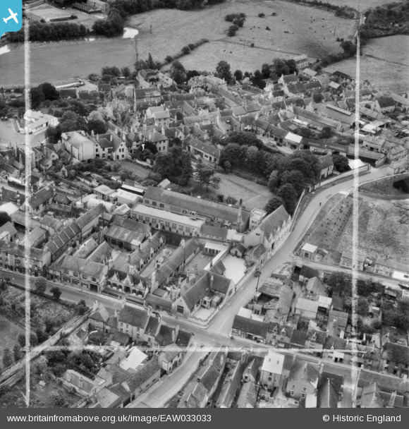
EAW033033 ENGLAND (1950). West Street, Scotsgate and environs, Stamford, 1950. This image was marked by Aerofilms Ltd for photo editing.
© Copyright OpenStreetMap contributors and licensed by the OpenStreetMap Foundation. 2026. Cartography is licensed as CC BY-SA.
Nearby Images (20)
Details
| Title | [EAW033033] West Street, Scotsgate and environs, Stamford, 1950. This image was marked by Aerofilms Ltd for photo editing. |
| Reference | EAW033033 |
| Date | 3-October-1950 |
| Link | |
| Place name | STAMFORD |
| Parish | STAMFORD |
| District | |
| Country | ENGLAND |
| Easting / Northing | 502650, 307118 |
| Longitude / Latitude | -0.48241956013115, 52.651716389226 |
| National Grid Reference | TF027071 |
Pins

Matt Aldred edob.mattaldred.com |
Wednesday 6th of March 2024 07:14:56 PM |


![[EAW033033] West Street, Scotsgate and environs, Stamford, 1950. This image was marked by Aerofilms Ltd for photo editing.](http://britainfromabove.org.uk/sites/all/libraries/aerofilms-images/public/100x100/EAW/033/EAW033033.jpg)
![[EAW033031] West Street and environs, Stamford, 1950. This image was marked by Aerofilms Ltd for photo editing.](http://britainfromabove.org.uk/sites/all/libraries/aerofilms-images/public/100x100/EAW/033/EAW033031.jpg)
![[EAW033032] West Street and environs, Stamford, 1950. This image was marked by Aerofilms Ltd for photo editing.](http://britainfromabove.org.uk/sites/all/libraries/aerofilms-images/public/100x100/EAW/033/EAW033032.jpg)
![[EAW033035] West Street and environs, Stamford, 1950. This image was marked by Aerofilms Ltd for photo editing.](http://britainfromabove.org.uk/sites/all/libraries/aerofilms-images/public/100x100/EAW/033/EAW033035.jpg)
![[EAW033034] West Street and allotments between Foundry Road and Rock Road, Stamford, 1950. This image was marked by Aerofilms Ltd for photo editing.](http://britainfromabove.org.uk/sites/all/libraries/aerofilms-images/public/100x100/EAW/033/EAW033034.jpg)
![[EAW033037] West Street, Scotgate and environs, Stamford, 1950. This image was marked by Aerofilms Ltd for photo editing.](http://britainfromabove.org.uk/sites/all/libraries/aerofilms-images/public/100x100/EAW/033/EAW033037.jpg)
![[EAW033045] The town, Stamford, from the south-west, 1950](http://britainfromabove.org.uk/sites/all/libraries/aerofilms-images/public/100x100/EAW/033/EAW033045.jpg)
![[EAW033036] West Street and environs, Stamford, 1950. This image was marked by Aerofilms Ltd for photo editing.](http://britainfromabove.org.uk/sites/all/libraries/aerofilms-images/public/100x100/EAW/033/EAW033036.jpg)
![[EAW033039] St Peter's Street, Foundry Road, Rock Road and environs, Stamford, 1950. This image was marked by Aerofilms Ltd for photo editing.](http://britainfromabove.org.uk/sites/all/libraries/aerofilms-images/public/100x100/EAW/033/EAW033039.jpg)
![[EAW033038] West Street and environs, Stamford, 1950. This image was marked by Aerofilms Ltd for photo editing.](http://britainfromabove.org.uk/sites/all/libraries/aerofilms-images/public/100x100/EAW/033/EAW033038.jpg)
![[EAW033046] The town, Stamford, from the east, 1950](http://britainfromabove.org.uk/sites/all/libraries/aerofilms-images/public/100x100/EAW/033/EAW033046.jpg)
![[EAW033040] West Street and environs, Stamford, 1950. This image was marked by Aerofilms Ltd for photo editing.](http://britainfromabove.org.uk/sites/all/libraries/aerofilms-images/public/100x100/EAW/033/EAW033040.jpg)
![[EAW043853] H.G. Twilley Ltd Buildings and adjacent Saw Mill on West Street and the town, Stamford, 1952. This image was marked by Aerofilms Ltd for photo editing.](http://britainfromabove.org.uk/sites/all/libraries/aerofilms-images/public/100x100/EAW/043/EAW043853.jpg)
![[EAW043860] Red Lion Square and the town centre, Stamford, 1952](http://britainfromabove.org.uk/sites/all/libraries/aerofilms-images/public/100x100/EAW/043/EAW043860.jpg)
![[EAW043858] H.G. Twilley Ltd Buildings and adjacent Saw Mill on West Street, Stamford, 1952. This image was marked by Aerofilms Ltd for photo editing.](http://britainfromabove.org.uk/sites/all/libraries/aerofilms-images/public/100x100/EAW/043/EAW043858.jpg)
![[EAW043855] H.G. Twilley Ltd Buildings and adjacent Saw Mill on West Street, Stamford, 1952. This image was marked by Aerofilms Ltd for photo editing.](http://britainfromabove.org.uk/sites/all/libraries/aerofilms-images/public/100x100/EAW/043/EAW043855.jpg)
![[EAW013392] All Saints' Church and the town centre, Stamford, 1948](http://britainfromabove.org.uk/sites/all/libraries/aerofilms-images/public/100x100/EAW/013/EAW013392.jpg)
![[EAW043854] H.G. Twilley Ltd Buildings and adjacent Saw Mill on West Street, Stamford, 1952. This image was marked by Aerofilms Ltd for photo editing.](http://britainfromabove.org.uk/sites/all/libraries/aerofilms-images/public/100x100/EAW/043/EAW043854.jpg)
![[EAW043851] H.G. Twilley Ltd Buildings and adjacent Saw Mill on West Street, Stamford, 1952. This image was marked by Aerofilms Ltd for photo editing.](http://britainfromabove.org.uk/sites/all/libraries/aerofilms-images/public/100x100/EAW/043/EAW043851.jpg)
![[EAW043856] H.G. Twilley Ltd Buildings and adjacent Saw Mill on West Street, Stamford, 1952. This image was marked by Aerofilms Ltd for photo editing.](http://britainfromabove.org.uk/sites/all/libraries/aerofilms-images/public/100x100/EAW/043/EAW043856.jpg)