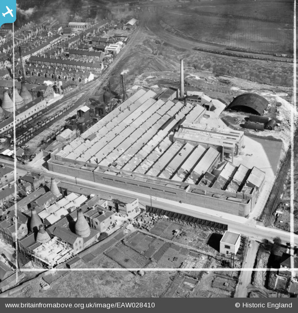
EAW028410 ENGLAND (1950). The Richards Tiles Ltd Brownhills Tile Works, Tunstall, 1950. This image was marked by Aerofilms Ltd for photo editing.
© Copyright OpenStreetMap contributors and licensed by the OpenStreetMap Foundation. 2026. Cartography is licensed as CC BY-SA.
Nearby Images (25)
Details
| Title | [EAW028410] The Richards Tiles Ltd Brownhills Tile Works, Tunstall, 1950. This image was marked by Aerofilms Ltd for photo editing. |
| Reference | EAW028410 |
| Date | 24-March-1950 |
| Link | |
| Place name | TUNSTALL |
| Parish | |
| District | |
| Country | ENGLAND |
| Easting / Northing | 386032, 350673 |
| Longitude / Latitude | -2.2084093953993, 53.05282949725 |
| National Grid Reference | SJ860507 |
Pins

Sparky |
Saturday 21st of October 2017 11:08:38 AM |


![[EAW028410] The Richards Tiles Ltd Brownhills Tile Works, Tunstall, 1950. This image was marked by Aerofilms Ltd for photo editing.](http://britainfromabove.org.uk/sites/all/libraries/aerofilms-images/public/100x100/EAW/028/EAW028410.jpg)
![[EAW028407] The Richards Tiles Ltd Brownhills Tile Works, Tunstall, 1950. This image was marked by Aerofilms Ltd for photo editing.](http://britainfromabove.org.uk/sites/all/libraries/aerofilms-images/public/100x100/EAW/028/EAW028407.jpg)
![[EAW028408] The Richards Tiles Ltd Brownhills Tile Works, Tunstall, 1950. This image was marked by Aerofilms Ltd for photo editing.](http://britainfromabove.org.uk/sites/all/libraries/aerofilms-images/public/100x100/EAW/028/EAW028408.jpg)
![[EPW047626] Brownhills Tile Works, Tunstall, 1935](http://britainfromabove.org.uk/sites/all/libraries/aerofilms-images/public/100x100/EPW/047/EPW047626.jpg)
![[EAW027946] The Richards Tiles Ltd Brownhills Tile Works, Tunstall, 1950. This image has been produced from a print.](http://britainfromabove.org.uk/sites/all/libraries/aerofilms-images/public/100x100/EAW/027/EAW027946.jpg)
![[EPW047627] Brownhills Tile Works, Tunstall, 1935](http://britainfromabove.org.uk/sites/all/libraries/aerofilms-images/public/100x100/EPW/047/EPW047627.jpg)
![[EAW028404] The Richards Tiles Ltd Brownhills Tile Works, Tunstall, 1950. This image was marked by Aerofilms Ltd for photo editing.](http://britainfromabove.org.uk/sites/all/libraries/aerofilms-images/public/100x100/EAW/028/EAW028404.jpg)
![[EPW047624] Brownhills Tile Works, Tunstall, 1935](http://britainfromabove.org.uk/sites/all/libraries/aerofilms-images/public/100x100/EPW/047/EPW047624.jpg)
![[EAW028405] The Richards Tiles Ltd Brownhills Tile Works, Tunstall, 1950. This image was marked by Aerofilms Ltd for photo editing.](http://britainfromabove.org.uk/sites/all/libraries/aerofilms-images/public/100x100/EAW/028/EAW028405.jpg)
![[EPW047628] Brownhills Tile Works, Tunstall, 1935](http://britainfromabove.org.uk/sites/all/libraries/aerofilms-images/public/100x100/EPW/047/EPW047628.jpg)
![[EPW047625] Brownhills Tile Works, Tunstall, 1935](http://britainfromabove.org.uk/sites/all/libraries/aerofilms-images/public/100x100/EPW/047/EPW047625.jpg)
![[EAW027940] The Richards Tiles Ltd Brownhills Tile Works, Tunstall, 1950](http://britainfromabove.org.uk/sites/all/libraries/aerofilms-images/public/100x100/EAW/027/EAW027940.jpg)
![[EAW027942] The Richards Tiles Ltd Brownhills Tile Works, Tunstall, 1950. This image was marked by Aerofilms Ltd for photo editing.](http://britainfromabove.org.uk/sites/all/libraries/aerofilms-images/public/100x100/EAW/027/EAW027942.jpg)
![[EAW027947] The Richards Tiles Ltd Brownhills Tile Works and Westport Lake, Tunstall, 1950. This image has been produced from a print.](http://britainfromabove.org.uk/sites/all/libraries/aerofilms-images/public/100x100/EAW/027/EAW027947.jpg)
![[EAW027944] The Richards Tiles Ltd Brownhills Tile Works, Tunstall, 1950. This image was marked by Aerofilms Ltd for photo editing.](http://britainfromabove.org.uk/sites/all/libraries/aerofilms-images/public/100x100/EAW/027/EAW027944.jpg)
![[EAW027941] The Richards Tiles Ltd Brownhills Tile Works, Tunstall, 1950](http://britainfromabove.org.uk/sites/all/libraries/aerofilms-images/public/100x100/EAW/027/EAW027941.jpg)
![[EAW028402] The Richards Tiles Ltd Brownhills Tile Works, Tunstall, 1950. This image was marked by Aerofilms Ltd for photo editing.](http://britainfromabove.org.uk/sites/all/libraries/aerofilms-images/public/100x100/EAW/028/EAW028402.jpg)
![[EPW047622] Brownhills Tile Works, Tunstall, 1935](http://britainfromabove.org.uk/sites/all/libraries/aerofilms-images/public/100x100/EPW/047/EPW047622.jpg)
![[EAW027945] The Richards Tiles Ltd Brownhills Tile Works, Tunstall, 1950. This image has been produced from a print marked by Aerofilms Ltd for photo editing.](http://britainfromabove.org.uk/sites/all/libraries/aerofilms-images/public/100x100/EAW/027/EAW027945.jpg)
![[EAW028403] The Richards Tiles Ltd Brownhills Tile Works, Tunstall, 1950. This image was marked by Aerofilms Ltd for photo editing.](http://britainfromabove.org.uk/sites/all/libraries/aerofilms-images/public/100x100/EAW/028/EAW028403.jpg)
![[EPW047623] Brownhills Tile Works, Tunstall, 1935](http://britainfromabove.org.uk/sites/all/libraries/aerofilms-images/public/100x100/EPW/047/EPW047623.jpg)
![[EAW027943] The Richards Tiles Ltd Brownhills Tile Works, Tunstall, 1950. This image was marked by Aerofilms Ltd for photo editing.](http://britainfromabove.org.uk/sites/all/libraries/aerofilms-images/public/100x100/EAW/027/EAW027943.jpg)
![[EAW028406] The Richards Tiles Ltd Brownhills Tile Works, Tunstall, 1950. This image was marked by Aerofilms Ltd for photo editing.](http://britainfromabove.org.uk/sites/all/libraries/aerofilms-images/public/100x100/EAW/028/EAW028406.jpg)
![[EAW028409] The Richards Tiles Ltd Brownhills Tile Works, Tunstall, 1950. This image was marked by Aerofilms Ltd for photo editing.](http://britainfromabove.org.uk/sites/all/libraries/aerofilms-images/public/100x100/EAW/028/EAW028409.jpg)
![[EPW038501] The Brownhills Tileries and the Brownhills Pottery Works, Tunstall, 1932](http://britainfromabove.org.uk/sites/all/libraries/aerofilms-images/public/100x100/EPW/038/EPW038501.jpg)
