
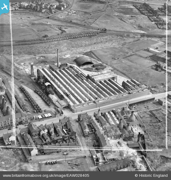
EAW028405 ENGLAND (1950). The Richards Tiles Ltd Brownhills Tile Works, Tunstall, 1950. This image was marked by Aerofilms Ltd for photo editing.
© Copyright OpenStreetMap contributors and licensed by the OpenStreetMap Foundation. 2026. Cartography is licensed as CC BY-SA.
Nearby Images (25)
EAW028405

EPW047627

EAW027944

EAW027940

EAW028404

EAW027942

EAW028402

EAW027941

EAW028407

EPW047624

EPW047628

EAW028410

EPW047625

EPW047626

EAW028408

EPW047622

EAW027946

EAW027945

EAW027947

EPW047623

EAW028403

EAW028406

EAW027943

EAW028409

EPW038501

Details
| Title | [EAW028405] The Richards Tiles Ltd Brownhills Tile Works, Tunstall, 1950. This image was marked by Aerofilms Ltd for photo editing. |
| Reference | EAW028405 |
| Date | 24-March-1950 |
| Link | |
| Place name | TUNSTALL |
| Parish | |
| District | |
| Country | ENGLAND |
| Easting / Northing | 386052, 350682 |
| Longitude / Latitude | -2.2081113775707, 53.052910930264 |
| National Grid Reference | SJ861507 |
Pins

bescotbeast |
Saturday 9th of May 2026 03:39:55 PM | |

Sparky |
Sunday 3rd of September 2017 08:12:17 PM |